Vysoké Mýto | |
|---|---|
_(cropped).jpg.webp) Přemysla Otakara II. Square | |
 Flag  Coat of arms | |
 Vysoké Mýto Location in the Czech Republic | |
| Coordinates: 49°57′12″N 16°9′42″E / 49.95333°N 16.16167°E | |
| Country | |
| Region | Pardubice |
| District | Ústí nad Orlicí |
| First mentioned | 1265 |
| Government | |
| • Mayor | František Jiraský |
| Area | |
| • Total | 42.03 km2 (16.23 sq mi) |
| Elevation | 284 m (932 ft) |
| Population (2023-01-01)[1] | |
| • Total | 12,333 |
| • Density | 290/km2 (760/sq mi) |
| Time zone | UTC+1 (CET) |
| • Summer (DST) | UTC+2 (CEST) |
| Postal code | 566 01 |
| Website | www |
Vysoké Mýto (Czech pronunciation: [ˈvɪsokɛː ˈmiːto]; German: Hohenmaut, also Hohenmauth) is a town in Ústí nad Orlicí District in the Pardubice Region of the Czech Republic. It has about 12,000 inhabitants. Its town square is the largest example of its type in the country. The historic town centre is well preserved and is protected by law as an urban monument zone.
Administrative parts

Vysoké Mýto is made up of town parts of Choceňské Předměstí, Litomyšlské Předměstí, Pražské Předměstí and Vysoké Mýto-Město, and villages of Brteč, Domoradice, Knířov, Lhůta, Svařeň and Vanice.
Etymology
The predecessor of the town was a small settlement by a trade route called Mýto (literally "toll"). After a new town was founded, it adopted the privilege of collecting the toll. The old settlement was renamed to Staré Mýto ("Old Toll") and the new town was called Vysoké Mýto ("High Toll"), probably referring to its location above the old settlement.[2]
Geography
Vysoké Mýto is located about 27 km (17 mi) southeast of Pardubice. It lies in the Svitavy Uplands. The highest point is at 436 m (1,430 ft) above sea level. The Loučná river flows through the town.
History

The first written mention of Vysoké Mýto is from 1265. It was founded shortly before this year by King Ottokar II as one of the trading centres on the trade route from Bohemia to Moravia, and was inhabited by German settlers. The town square and the network of streets were built in a regular shape, which is preserved to this day. Stone walls with three gates were gradually built around the whole town.[2]
In the early 14th century, Vysoké Mýto became a dowry town administered by Elizabeth Richeza of Poland. Thanks to its location on a busy mercantile road it soon became rich. During the Hussite Wars, the town was occupied several times. Most of the German population left the town and Czech citizens became the majority. After the wars, it became royal town of King Sigismund, who donated it to his wife Barbara of Cilli and it became again a dowry town.[2]
Vysoké Mýto was devastated by fires between 1461 and 1517. Thanks to its wealth, the town recovered and new buildings were building, including stone houses on the square, the new town hall, and the Church of the Holy Trinity. In the 16th century, the town prospered and crafts developed. Cloth and knives were exported abroad. The prosperity ended with the Thirty Years' War and several fires in the 18th century.[2]
During the 19th century, new development occurred, and the town became a cultural centre. A Czech-language theatre was established in 1825, the first public library in the region was established in 1839, and the town museum was founded in 1871. At the end of the 19th century, Vysoké Mýto was industrialized and two big engineering and machine-building companies were founded.[2]
Until 1918, Vysoké Mýto was part of Austria-Hungary, head of the district of the same name, one of the 94 Bezirkshauptmannschaften in Bohemia.[3]
Demographics
|
|
| ||||||||||||||||||||||||||||||||||||||||||||||||||||||
| Source: Censuses[4][5] | ||||||||||||||||||||||||||||||||||||||||||||||||||||||||
Economy
The most important employer in the town is Iveco Czech Republic and its Iveco Bus factory (previously Karosa), which produces buses under the brands Irisbus Crossway, Irisbus Arway and Iveco Urbanway. With more than 3,000 employees, Iveco Czech Republic is the largest industrial company in the Pardubice Region.[6]
Transport
The I/35 road (part of the European route E442), which replaces the unfinished section of the D35 motorway from Olomouc to the Hradec Králové Region, passes through the town.
Vysoké Mýto lies on a railway line heading from Litomyšl to Choceň.[7]
Sport
The town's football club is SK Vysoké Mýto. It plays in lower amateur tiers.
Sights
.jpg.webp)
The quadrangle square named Přemysla Otakara II. Square is the largest square of its type in the Czech Republic.[8] The Old Town Hall from 1433 is one of the oldest stone buildings in the town. It was rebuilt several times, last in 1828 in the Empire style. Today it houses the tourist information centre, the Town Gallery and an exposition on the manufacture of car bodies. In the middle of the square is a Baroque Marian column from 1714.[2]
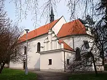
The Church of Saint Lawrence is a large cathedral from the second half of the 13th century. It was reconstructed after the fire in the 16th century, and the near Renaissance belfry was erected in 1585. The current appearance of the church is result of purist restoration from the late 19th century. Nowadays the premises of the belfry are used by the Town Gallery.[2]
The Church of the Holy Trinity was built in the Renaissance style with Gothic elements in 1543.[2]
Most of the town fortifications from the 14th century were demolished in the 18th century. Some fragments are preserved to this day, including the Prague Gate and Litomyšl Gate. The tower of the Prague Gate is open to the public as a lookout tower.[2]
The Vysoké Mýto Regional Museum, which was founded in 1871, is the oldest town museum in the country.[2]
Notable people
- Bedřich Bridel (1619–1680), writer, poet and missionary
- Dismas Hataš (1724–1777), violinist and composer
- Alois Vojtěch Šembera (1807–1882), linguist and historian of literature
- Josef Jireček (1825–1888), scholar
- Hermenegild Jireček (1827–1909), jurisconsult
- Hermann Škorpil (1858–1923), Czech-Bulgarian archaeologist and museum worker
- Karel Škorpil (1859–1944), Czech-Bulgarian archaeologist and museum worker
- František Ventura (1894–1969), equestrian, Olympic winner
- Maria Tauberová (1911–2003), opera singer
- Ladislav Trpkoš (1915–2004), basketball player
- Zdeněk Mlynář (1930–1997), politologist and politician
- Marie Málková (born 1941), actress
- Josef Krečmer (born 1958), violoncellist
- Luboš Kubík (born 1964), football player and coach
- Jan Jiraský (born 1973), pianist and pedagogue
Twin towns – sister cities
Vysoké Mýto is twinned with:[9]
 Dolni Chiflik, Bulgaria
 Korbach, Germany
 Odessos District (Varna), Bulgaria
 Ozorków, Poland
 Pyrzyce, Poland
 Spišská Belá, Slovakia
References
- ↑ "Population of Municipalities – 1 January 2023". Czech Statistical Office. 23 May 2023.
- 1 2 3 4 5 6 7 8 9 10 "History". Město Vysoké Mýto. Retrieved 6 October 2021.
- ↑ Die postalischen Abstempelungen auf den österreichischen Postwertzeichen-Ausgaben 1867, 1883 und 1890, Wilhelm Klein, 1967
- ↑ "Historický lexikon obcí České republiky 1869–2011 – Okres Ústí nad Orlicí" (in Czech). Czech Statistical Office. 21 December 2015. pp. 15–16.
- ↑ "Population Census 2021: Population by sex". Public Database. Czech Statistical Office. 27 March 2021.
- ↑ "Registr ekonomických subjektů". Business Register (in Czech). Czech Statistical Office. Retrieved 28 June 2023.
- ↑ "Detail stanice Vysoké Mýto" (in Czech). České dráhy. Retrieved 28 June 2023.
- ↑ "About town". Město Vysoké Mýto. Retrieved 6 October 2021.
- ↑ "Partnerská města" (in Czech). Město Vysoké Mýto. Retrieved 28 June 2023.