| Holzbach | |
|---|---|
 The Holzbach at Thailen | |
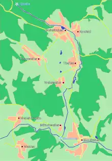
 Map of the Holzbach | |
| Location | |
| Location | Hunsrück
northern Saarland
|
| Reference no. | DE: 264664 |
| Physical characteristics | |
| Source | |
| • location | north of Weiskirchen |
| • coordinates | 49°34′42″N 6°46′27″E / 49.57833°N 6.77417°E |
| • elevation | 565 m above sea level (NN) |
| Mouth | |
• location | at Nunkirchen into the Losheimer Bach |
• coordinates | 49°29′29.5″N 6°49′10″E / 49.491528°N 6.81944°E |
• elevation | 256 m above sea level (NN) |
| Length | 13.23 km [1] |
| Basin size | 26.0 km² [1] |
| Basin features | |
| Progression | Losheimer Bach → Prims → Saar → Moselle → Rhine → North Sea |
| River system | Rhine |
| Landmarks |
|

Bridge over the Holzbach in the Kneipp facility at Thailen
The Holzbach is a stream in the state of Saarland, Germany, in the uplands of the Schwarzwälder Hochwald. It flows into the Losheimer Bach at Nunkirchen.
Geography
Course
The Holzbach rises in the Hunsrück mountains at a height of 565 m above NHN north of Weiskirchen and empties into the Losheimer Bach at Nunkirchen at a height of 256 m.
Tributaries
- Flachsbach (left)
- Schlittentaler Bach (left)
- Ruwerbach (right)
Settlements
The Holzbach flows through the following settlements:
- Weiskirchen
- Konfeld
- Thailen
- Batschweiler
- Weierweiler
- Münchweiler
- Nunkirchen
See also
References
- 1 2 WRRL land management plan for the Saarland December 2009, p. 11 at the Wayback Machine (archived 2017-03-30) (pdf; 783 kB)
This article is issued from Wikipedia. The text is licensed under Creative Commons - Attribution - Sharealike. Additional terms may apply for the media files.