| Horn, Hornbach | |
|---|---|
 | |
 | |
| Location | |
| Countries | France and Germany |
| Region | Grand Est |
| State | Rhineland-Palatinate |
| Physical characteristics | |
| Source | Entenbaechelthal |
| • location | Bitche, Moselle (France) |
| • coordinates | 49°01′28″N 7°26′37″E / 49.0245°N 7.4436°E |
| • elevation | 315 m (1,033 ft) |
| Mouth | Zweibrücken, RP (Germany) |
• location | Schwarzbach |
• coordinates | 49°15′17″N 7°20′12″E / 49.2548°N 7.3366°E |
• elevation | 219 m (719 ft) |
| Length | 33 km (21 mi) |
| Basin size | 150 km2 (58 sq mi) |
| Basin features | |
| Progression | Schwarzbach→ Blies→ Saar→ Moselle→ Rhine→ North Sea |
| Landmarks | Hasselfurth Pond, Citadel of Bitche |
| Tributaries | |
| • left | Lebach, Rothlambach, Schorbach, Hasselbach, Neubach, Kumper Bach, Bleischbach, Klassbach, Breidenbach, Weiherbach, Grosssteinbach, Wiesengraben, Muehlbach, Schwalb, Unterbeiwaldgraben, Bickenalb |
| • right | Musbach, Roelbach, Schwartzenbach, Schweixer Bach, Trualbe/Schwarzbach, Strolbach, Altbach, Bottenbach, Felsalb, Kirschbach, Mauschbach, Buchholzgraben, Althornbach, Atzenbach |
| Waterbodies | Entenbaechelweiher, Hasselfurther Weiher |
The river Horn (French: Horn; German: Hornbach) is a left tributary of Schwarzbach flowing through the department of Moselle, in northeastern France, and the state of Rhineland-Palatinate, in southwestern Germany.
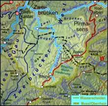
The Horn's headwaters rise in the French town of Bitche, in the Moselle Department, following a north by north-eastern course, before forming a part of the border between France and Germany. As the Franco-German border takes a sharp turn to the west, the Horn continues into Germany. Here, it follows a roughly north-western course, ending in the German town of Zweibrücken, emptying into the Schwarzbach. Its length in France is 27.6 km (17.1 mi).[1]
See also
References
This article is issued from Wikipedia. The text is licensed under Creative Commons - Attribution - Sharealike. Additional terms may apply for the media files.