.svg.png.webp) | ||||
|---|---|---|---|---|
| Malabang–Marawi–Iligan Road | ||||
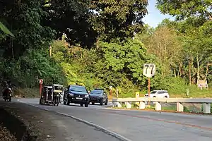
 Reassurance Marker at Balo-i, Lanao del Norte | ||||
| Route information | ||||
| Maintained by Department of Public Works and Highways | ||||
| Length | 30 km (19 mi) | |||
| Component highways | ||||
| Major junctions | ||||
| South end | ||||
| North end | ||||
| Location | ||||
| Country | Philippines | |||
| Provinces | Lanao del Norte, Lanao del Sur | |||
| Major cities | Marawi, Iligan | |||
| Towns | Saguiaran, Pantar, Baloi | |||
| Highway system | ||||
| ||||
| ||||
The Iligan–Marawi Road, officially the Malabang–Marawi–Iligan Road, is a 30-kilometer (19 mi), two-lane national primary road that connects the city of Iligan in Lanao del Sur to the municipality of Malabang in Lanao del Norte.[1][2] It traverses through the cities and municipalities of Lanao del Sur and Lanao del Norte.
The highway is designated as National Route 77 (N77) of the Philippine highway network. It comprises Narciso Ramos Highway (Malabang-Marawi), Amai Pakpak Avenue (Marawi), Iligan-Marawi Road proper (Marawi-Iligan).
References
- ↑ "Lanao del Norte 1st". www.dpwh.gov.ph. Retrieved August 4, 2018.
- ↑ "Lanao del Norte 2nd". www.dpwh.gov.ph. Retrieved August 4, 2018.
This article is issued from Wikipedia. The text is licensed under Creative Commons - Attribution - Sharealike. Additional terms may apply for the media files.