Inden | |
|---|---|
 | |
 Flag _COA.svg.png.webp) Coat of arms | |
Location of Inden within Düren district 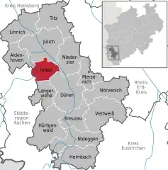 | |
 Inden  Inden | |
| Coordinates: 50°50′48″N 06°21′28″E / 50.84667°N 6.35778°E | |
| Country | Germany |
| State | North Rhine-Westphalia |
| Admin. region | Köln |
| District | Düren |
| Subdivisions | 7 |
| Government | |
| • Mayor (2020–25) | Stefan Pfennings[1] |
| Area | |
| • Total | 35.92 km2 (13.87 sq mi) |
| Elevation | 106 m (348 ft) |
| Population (2021-12-31)[2] | |
| • Total | 7,418 |
| • Density | 210/km2 (530/sq mi) |
| Time zone | UTC+01:00 (CET) |
| • Summer (DST) | UTC+02:00 (CEST) |
| Postal codes | 52459 |
| Dialling codes | 02465 |
| Vehicle registration | DN |
| Website | www.inden.de |
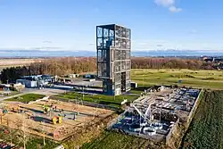
Inden is a municipality in the district of Düren in the state of North Rhine-Westphalia, Germany. It is located on the river Inde, approx. 10 km north-west of Düren. In the area around Inden lignite is extracted in open-pit mines. One mine is being rehabilitated with lake, park, solar power and energy storage.[3] Several hundreds of inhabitants have been resettled in the 1990s and 2000s because of these activities.
Town division
Districts:
- Frenz
- Inden/Altdorf
- Lamersdorf
- Lucherberg
- Schophoven
- Viehöven
.jpg.webp)
Inden-Schophoven Müllenark mill
References
- ↑ Wahlergebnisse in NRW Kommunalwahlen 2020, Land Nordrhein-Westfalen, accessed 19 June 2021.
- ↑ "Bevölkerung der Gemeinden Nordrhein-Westfalens am 31. Dezember 2021" (in German). Landesbetrieb Information und Technik NRW. Retrieved 20 June 2022.
- ↑ "RWE solar-plus-storage project at German lignite mine nears completion". Energy Storage News. 28 April 2022.
External links
![]() Media related to Inden (Rheinland) at Wikimedia Commons
Media related to Inden (Rheinland) at Wikimedia Commons
Towns and municipalities in Düren (district) | ||
|---|---|---|
Coat of Arms of Düren district | ||
This article is issued from Wikipedia. The text is licensed under Creative Commons - Attribution - Sharealike. Additional terms may apply for the media files.