Janjanbureh | |
|---|---|
 | |
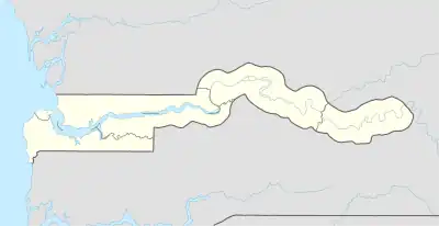
 Janjanbureh Location in the Gambia | |
| Coordinates: 13°32′2.87″N 14°45′58.15″W / 13.5341306°N 14.7661528°W | |
| Country | |
| Division | Central River Division |
Janjanbureh or Jangjangbureh is a town, founded in 1823, on Janjanbureh Island, also known as MacCarthy Island, in the Gambia River in eastern Gambia.[1][2] Until 1995, it was known as Georgetown and was the second largest town in the country. It is the capital of Janjanbureh Local Government Area (formerly the Central River Division), and the Janjanbureh district. The population of the Janjanbureh LGA was 127,333 at the 2013 population census.[3]
History
MacCarthy Island, then known as Lemain Island, was purchased by the British captain Alexander Grant in 1823 in exchange for annual payments to the local chief, intended as a settlement for freed slaves.[4] By the 1840s the trading post was doing steady business in hides, wax, and ivory; it was the furthest upriver post the colonial administration controlled.[5]
In 1880 the town had a population of 1263, of whom only one was a European.[5]
Janjanbureh was the birthplace of the late Yale University historian Lamin Sanneh.[6]
Janjanbureh today
The town is best known as home to Gambia's main prison. The Wassu stone circles, a major tourist attraction, lie 22 km northwest of Lamin Koto, on the north bank across from Janjanbureh.
The island is known locally as MacCarthy Island and is located in what used to be called MacCarthy Island Division. The island is accessed by bridge from the south bank, and small boat ferries or the government ferry from the north bank. In 1995, both the city of Georgetown and MacCarthy Island were renamed Janjanbureh respectively.
Climate
| Climate data for Janjanbureh (1991–2020) | |||||||||||||
|---|---|---|---|---|---|---|---|---|---|---|---|---|---|
| Month | Jan | Feb | Mar | Apr | May | Jun | Jul | Aug | Sep | Oct | Nov | Dec | Year |
| Mean daily maximum °C (°F) | 34.9 (94.8) |
37.3 (99.1) |
39.4 (102.9) |
40.6 (105.1) |
40.1 (104.2) |
37.2 (99.0) |
33.3 (91.9) |
32.0 (89.6) |
32.3 (90.1) |
34.3 (93.7) |
36.1 (97.0) |
35.3 (95.5) |
36.1 (97.0) |
| Daily mean °C (°F) | 24.7 (76.5) |
27.0 (80.6) |
29.2 (84.6) |
31.0 (87.8) |
31.8 (89.2) |
30.8 (87.4) |
28.5 (83.3) |
27.7 (81.9) |
27.6 (81.7) |
28.6 (83.5) |
27.2 (81.0) |
25.2 (77.4) |
28.3 (82.9) |
| Mean daily minimum °C (°F) | 14.7 (58.5) |
16.9 (62.4) |
19.1 (66.4) |
21.4 (70.5) |
23.5 (74.3) |
24.5 (76.1) |
23.7 (74.7) |
23.5 (74.3) |
23.1 (73.6) |
22.9 (73.2) |
18.3 (64.9) |
15.3 (59.5) |
20.6 (69.1) |
| Average precipitation mm (inches) | 0.3 (0.01) |
0.0 (0.0) |
0.0 (0.0) |
0.0 (0.0) |
10.2 (0.40) |
79.4 (3.13) |
192.0 (7.56) |
272.5 (10.73) |
206.9 (8.15) |
56.2 (2.21) |
0.7 (0.03) |
0.0 (0.0) |
818.2 (32.21) |
| Average precipitation days (≥ 1.0 mm) | 0.1 | 0.0 | 0.0 | 0.0 | 0.7 | 4.9 | 10.9 | 15.3 | 13.1 | 4.2 | 0.1 | 0.0 | 49.3 |
| Source: NOAA[7] | |||||||||||||
Gallery
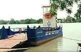
 Jajanbureh ferry
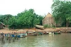
 The slave house, a museum of the slave trade
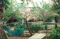
 Hut at the Jangjangbureh Camp
References
- ↑ Gailey, Harry A. (1964). A History of The Gambia. London: Routledge and Kegan Paul.
- ↑ Gray, J.M. (1940). History of The Gambia. Cambridge: Cambridge University Press.
- ↑ "Distribution of Population by Gender and LGA". GBoS. 2017-09-20. Retrieved 2022-03-10.
- ↑ Britannica, The Editors of Encyclopaedia. "Georgetown". Encyclopedia Britannica, 12 Jan. 2012, https://www.britannica.com/place/Georgetown-The-Gambia. Accessed 29 July 2023.
- 1 2 Glovsky, David (2020). Belonging beyond boundaries : constructing a transnational community in a West African borderland (PhD). p. 96-7. Retrieved 28 July 2023.
- ↑ Seelye, Katharine Q. (2019-01-11). "Lamin Sanneh, Scholar of Islam and Christianity, Dies at 76". The New York Times. ISSN 0362-4331. Retrieved 2020-06-09.
- ↑ "World Meteorological Organization Climate Normals for 1991-2020 — Janjanbureh". National Oceanic and Atmospheric Administration. Retrieved January 4, 2024.