Tabanan Regency
Kabupaten Tabanan ᬓᬩᬸᬧᬢᬾᬦ᭄ᬢᬩᬦᬦ᭄ | |
|---|---|
 | |
 Seal | |
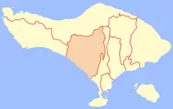 Location within Bali | |
| Coordinates: 8°33′4.13″S 115°7′17.81″E / 8.5511472°S 115.1216139°E | |
| Country | |
| Province | |
| Capital | Tabanan |
| Area | |
| • Total | 839.33 km2 (324.07 sq mi) |
| Population (mid 2022 estimate)[1] | |
| • Total | 469,340 |
| • Density | 560/km2 (1,400/sq mi) |
| Time zone | UTC+8 (ICST) |
| Area code | (+62) 361 |
| Website | tabanankab.go.id |


Tabanan is one of the regencies (kabupaten) in Bali, Indonesia. Relatively underdeveloped (compared with Badung and Denpasar to the east), Tabanan Regency has an area of 839.33 km2 and had a population of 386,850 in 2000, rising to 420,913 in 2010,[2] then 461,630 at the 2020 census;[3] the official estimate as at mid 2022 was 469,340.[1] Its regency seat is the town of Tabanan. One of the popular tourism attractions located in Tabanan is the offshore rocky islet of Tanah Lot.
Administrative districts
The regency is divided into ten districts (kecamatan), tabulated below with their areas and population totals at the 2010 census[2] and the 2020 census,[3] together with the official estimates as at mid 2022.[1] The table also includes the locations of the district administrative centres, the number of administrative villages in each district (all classed as rural desa), and its postal codes.
| Kode Wilayah | Name of District (kecamatan) | Area in km2 | Pop'n census 2010 | Pop'n census 2020 | Pop'n estimate mid 2022 | Admin centre | No. of villages | Post codes |
|---|---|---|---|---|---|---|---|---|
| 51.02.01 | Selemadeg | 52.05 | 19,262 | 21,874 | 22,400 | Bajera | 10 | 82164 |
| 51.02.02 | Selemadeg Timur (East Selemadeg) | 54.78 | 21,154 | 23,826 | 24,300 | Megati | 10 | 82160 |
| 51.02.03 | Selemadeg Barat (West Selemadeg) | 120.15 | 18,809 | 21,079 | 21,500 | Antosari | 11 | 82162 |
| 51.02.04 | Kerambitan | 42.39 | 37,704 | 41,766 | 42,500 | Kerambitan | 15 | 82161 |
| 51.02.05 | Tabanan (district) | 51.40 | 70,526 | 76,235 | 77,300 | Tabanan (town) | 12 | 82111 - 82115 |
| 51.02.06 | Kediri | 53.60 | 84,215 | 90,491 | 91,600 | Kediri | 15 | 82121 - 82123 |
| 51.02.07 | Marga | 44.79 | 40,353 | 42,898 | 43,400 | Marga | 16 | 82181 |
| 51.02.09 | Baturiti | 99.17 | 46,425 | 51,381 | 52,300 | Baturiti | 12 | 82191 |
| 51.02.08 | Penebel | 141.98 | 44,104 | 49,637 | 50,700 | Penebel | 18 | 82152 |
| 51.02.10 | Pupuan | 179.02 | 38,361 | 42,443 | 43,200 | Pupuan | 14 | 82163 |
| Totals | 839.33 | 420,913 | 461,630 | 469,340 | 133 |
The administrative centre of Selemadeg District is at Bajera, that of Selemadeg Timur is at Megati, and that of Selemadeg Barat is at Antosari; the other districts share the same name as their administrative centre. Kediti and Tabanan Districts in the southeast of the regency are within the official metropolitan area of Greater Denpasar (Sarbagita); Pupuan, Selemadeg Barat, Selemadeg, and Selemadeg Timur Districts together constitute the western half of the Regency.
Jatiluwih
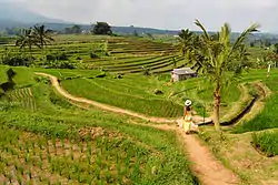
Jatiluwih village in Penebel District, north of Tabanan, has paddy fields following the contours of terraced land against the background of spellbinding Mount Batukaru and Mount Agung use traditional Balinese irrigation known as subak, Bali's community-based water control management system. Lies at an altitude of 700 meters, the cool atmosphere of more original beautiful Jatiluwih is better than the most well-known Tegallalang which has plenty of cafes and souvenir shops. Two routes to Jatiluwih are Denpasar>Kediri>Tabanan>Penebel>Jatiluwih or Denpasar>Mengwi>Baturiti>Jatiluwih.[4] Jatiluwih is one of the five rice terraces that describe the "Subak" water management system which has gained acknowledgment from UNESCO as part of the world's cultural heritage.[5]
Tourism development control
To preserve the largest area of 53,000 hectares of agriculture fields on the island, the Tabanan Regency Administration would not allow the development of star-rated city hotels anymore, unless tourism facilities with a commitment to environmental conservation would be allowed with 30 percent of buildings and 70 percent had to be left naturally as paddy field or plantation. The administration has also decided 300-hectare protected paddy field zone with a 100-hectare housing zone lies outside the protected zone. For visitors, it is possible to visit the 300-hectare on foot (about 31⁄2 hrs trekking) or with an e-bike tour that the local villagers have organized since 2017 (about 1 hour).
Climate
Tabanan has a tropical rainforest climate (Af) with moderate rainfall from April to September and heavy rainfall from October to March.
| Climate data for Tabanan | |||||||||||||
|---|---|---|---|---|---|---|---|---|---|---|---|---|---|
| Month | Jan | Feb | Mar | Apr | May | Jun | Jul | Aug | Sep | Oct | Nov | Dec | Year |
| Mean daily maximum °C (°F) | 30.4 (86.7) |
30.5 (86.9) |
30.6 (87.1) |
31.1 (88.0) |
30.8 (87.4) |
30.1 (86.2) |
29.4 (84.9) |
29.5 (85.1) |
30.3 (86.5) |
31.1 (88.0) |
31.2 (88.2) |
30.8 (87.4) |
30.5 (86.9) |
| Daily mean °C (°F) | 26.3 (79.3) |
26.3 (79.3) |
26.2 (79.2) |
26.3 (79.3) |
26.0 (78.8) |
25.3 (77.5) |
24.9 (76.8) |
24.9 (76.8) |
25.6 (78.1) |
26.3 (79.3) |
26.5 (79.7) |
26.4 (79.5) |
25.9 (78.6) |
| Mean daily minimum °C (°F) | 22.2 (72.0) |
22.2 (72.0) |
21.9 (71.4) |
21.6 (70.9) |
21.2 (70.2) |
20.5 (68.9) |
20.4 (68.7) |
20.4 (68.7) |
20.9 (69.6) |
21.5 (70.7) |
21.9 (71.4) |
22.1 (71.8) |
21.4 (70.5) |
| Average rainfall mm (inches) | 314 (12.4) |
260 (10.2) |
221 (8.7) |
102 (4.0) |
111 (4.4) |
110 (4.3) |
135 (5.3) |
69 (2.7) |
108 (4.3) |
213 (8.4) |
237 (9.3) |
298 (11.7) |
2,178 (85.7) |
| Source: Climate-Data.org[6] | |||||||||||||
References
- 1 2 3 Badan Pusat Statistik, Jakarta, 2023, Kabupaten Tabanan Dalam Angka 2023 (Katalog-BPS 1102001.5102)
- 1 2 Biro Pusat Statistik, Jakarta, 2011.
- 1 2 Badan Pusat Statistik, Jakarta, 2021.
- ↑ "Jatiluwih's beautiful terraced rice fields | The Jakarta Post". Archived from the original on 2011-06-07.
- ↑ "Cultural Landscape of Bali Province: The Subak System as a Manifestation of the Tri Hita Karana Philosophy".
- ↑ "Climate: Tabanan". Climate-Data.org. Retrieved 17 November 2020.
External links
 Tabanan travel guide from Wikivoyage
 Media related to Tabanan Regency at Wikimedia Commons
- (in Indonesian) Official website