| Lake Jed Johnson | |
|---|---|
 | |
 Lake Jed Johnson  Lake Jed Johnson | |
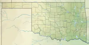
| Location | Wichita Mountains, Comanche County, Oklahoma, US |
| Coordinates | 34°43′45″N 98°36′0″W / 34.72917°N 98.60000°W |
| Type | reservoir |
| Primary inflows | Blue Beaver Creek |
| Primary outflows | Blue Beaver Creek |
| Catchment area | 5.35 sq mi (13.9 km2) |
| Basin countries | United States |
| Managing agency | U.S. Fish and Wildlife Service |
| Built | 1940 |
| Surface area | 57.5 acres (23.3 ha) |
| Water volume | 1,190 acre⋅ft (0.00147 km3) |
| Surface elevation | 1,608 feet (490 m) |
| Settlements | Cache, Medicine Park, Meers |
| References | [1][2] |
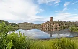
Lake Jed Johnson, named for Jed Johnson (1888–1963), is third largest of thirteen small reservoirs in the Wichita Mountains National Wildlife Refuge, located in southwestern Oklahoma. Lawton, Oklahoma, southeast of the lake and the fourth largest city in the state, is the nearest major population center. Smaller communities of Cache, Medicine Park and Meers lie north of the lake.
General description
Created in 1940 by the construction of the concrete Jed Johnson Dam across Blue Beaver Creek in Comanche County, Oklahoma, Lake Jed Johnson has a surface area of 57.5 acres (233,000 m2). Its primary purpose is preservation of wildlife habitat. and can be accessed by a boat ramp. Fishing is allowed, using hand-powered boats or other boats less than 14 feet (4.3 m) long and powered with trolling motors.[3]
The surrounding area is home to deer, elk, Longhorn cattle and bison, and there are many opportunities for boating, fishing, hunting, and hiking throughout the refuge.[3]
Tower and trail
The Jed Johnson Tower sits atop a hill near the lake. It is a former fire watch station that was constructed by the Civilian Conservation Corps (CCC) in 1941, before the U.S. formally entered World War II. Now abandoned, it is not open to visitors, reportedly because it is considered structurally unsound. The tower is approximately 60 feet (18 m) tall.[4]
The tower can be accessed using the Jed Johnson Trail, which is a 1 mile (1.6 km) long out-and-back trail from the lake shore. Primarily used for hiking, walking, trail running, and nature trips, the trail has an elevation gain of 68 feet (21 m) and is accessible year-round. Users may bring along dogs, but only if they are on leash at all times.[5]
See also
References
- ↑ Varghese, Saji (1998). "Hydrologic Investigation of Red River Basin" (pdf). Oklahoma Water Resources Board. OK.gov - Oklahoma State Portal. pp. 76, 78. Retrieved 2012-10-03.
- ↑ "Blue Beaver Creek near Cache, Oklahoma (Station 07311200)". Hydrologic Benchmark Network ~ U.S. Geological Survey. U.S. Department of the Interior.
- 1 2 "Lake Jed Johnson Dam - Wichita Mountains Refuge, OK." Waymarking. May26, 2015. Accessed May 23, 2018.
- ↑ “Jed Johnson Lake/Central Peak, February 21, 2015”. Accessed May 23, 2018
- ↑ "Jed Johnson Tower Trail." All Trails. Undated. Accessed May 23, 2018
External links
- "Blue Beaver Creek". Geographic Names Information System. United States Geological Survey, United States Department of the Interior. Retrieved 2012-10-03.
- "Lake Jed Johnson". Geographic Names Information System. United States Geological Survey, United States Department of the Interior. Retrieved 2009-05-04.
- Wichita Mountains National Wildlife Refuge Archived 2011-09-02 at the Wayback Machine