Junction City, Georgia | |
|---|---|
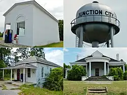 Junction City (in 2012) | |
 Location in Talbot County and the state of Georgia | |
| Coordinates: 32°36′11″N 84°27′29″W / 32.60306°N 84.45806°W | |
| Country | United States |
| State | Georgia |
| County | Talbot |
| Area | |
| • Total | 2.48 sq mi (6.42 km2) |
| • Land | 2.35 sq mi (6.09 km2) |
| • Water | 0.13 sq mi (0.33 km2) |
| Elevation | 689 ft (210 m) |
| Population (2020) | |
| • Total | 138 |
| • Density | 58.70/sq mi (22.67/km2) |
| Time zone | UTC-5 (Eastern (EST)) |
| • Summer (DST) | UTC-4 (EDT) |
| ZIP code | 31812 |
| Area code | 706 |
| FIPS code | 13-42800[3] |
| GNIS feature ID | 316309[2] |
Junction City is a town in Talbot County, Georgia, United States. The population was 179 at the 2000 census.
History
Junction City was platted at the site of a railway junction, hence the name.[4] The Georgia General Assembly incorporated Junction City as a town in 1906.[5]
Geography
Junction City is located at 32°36′11″N 84°27′29″W / 32.60306°N 84.45806°W (32.603083, -84.458190).[6]
The city is located along the Fall Line Freeway (GA state routes 96 and 540), which runs west to east through the town, leading east 15 mi (24 km) to Butler and west 39 mi (63 km) to Columbus. Georgia State Route 90 also runs through the town, leading northwest 8 mi (13 km) to Talbotton, the county seat, and southeast 8 mi (13 km) to Mauk.
According to the United States Census Bureau, the town has a total area of 2.5 square miles (6.5 km2), of which 2.5 square miles (6.5 km2) is land and 0.1 square miles (0.26 km2) (2.35%) is water.
Demographics
| Census | Pop. | Note | %± |
|---|---|---|---|
| 1910 | 225 | — | |
| 1920 | 323 | 43.6% | |
| 1930 | 341 | 5.6% | |
| 1940 | 326 | −4.4% | |
| 1950 | 259 | −20.6% | |
| 1960 | 226 | −12.7% | |
| 1970 | 269 | 19.0% | |
| 1980 | 254 | −5.6% | |
| 1990 | 182 | −28.3% | |
| 2000 | 179 | −1.6% | |
| 2010 | 177 | −1.1% | |
| 2020 | 138 | −22.0% | |
| U.S. Decennial Census[7] 1850-1870[8] 1880[9] 1890-1910[10] 1920-1930[11] 1930-1940[12] 1940-1950[13] 1960-1980[14] 1980-2000[15] | |||
Junction City first appeared in the 1910 U.S. Census.[10]
| Race / Ethnicity | Pop 2000[16] | Pop 2010[17] | Pop 2020[18] | % 2000 | % 2010 | % 2020 |
|---|---|---|---|---|---|---|
| White alone (NH) | 68 | 35 | 38 | 37.99% | 19.77% | 27.54% |
| Black or African American alone (NH) | 108 | 135 | 98 | 60.34% | 76.27% | 71.01% |
| Native American or Alaska Native alone (NH) | 2 | 0 | 0 | 1.12% | 0.00% | 0.00% |
| Asian alone (NH) | 0 | 0 | 0 | 0.00% | 0.00% | 0.00% |
| Pacific Islander alone (NH) | 0 | 0 | 0 | 0.00% | 0.00% | 0.00% |
| Some Other Race alone (NH) | 0 | 0 | 0 | 0.00% | 0.00% | 0.00% |
| Mixed Race/Multi-Racial (NH) | 0 | 1 | 2 | 0.00% | 0.56% | 1.45% |
| Hispanic or Latino (any race) | 1 | 6 | 0 | 0.56% | 3.39% | 0.00% |
| Total | 179 | 177 | 138 | 100.00% | 100.00% | 100.00% |
2000
As of the census[3] of 2000, there were 179 people, 69 households, and 46 families residing in the town. The population density was 71.9 inhabitants per square mile (27.8/km2). There were 91 housing units at an average density of 36.6 per square mile (14.1/km2). The racial makeup of the town was 38.55% White, 60.34% African American and 1.12% Native American. Hispanic or Latino of any race were 0.56% of the population.
There were 69 households, out of which 34.8% had children under the age of 18 living with them, 50.7% were married couples living together, 11.6% had a female householder with no husband present, and 33.3% were non-families. 29.0% of all households were made up of individuals, and 11.6% had someone living alone who was 65 years of age or older. The average household size was 2.59 and the average family size was 3.24.
In the town, the population was spread out, with 24.6% under the age of 18, 6.1% from 18 to 24, 27.4% from 25 to 44, 24.6% from 45 to 64, and 17.3% who were 65 years of age or older. The median age was 40 years. For every 100 females, there were 101.1 males. For every 100 females age 18 and over, there were 104.5 males.
The median income for a household in the town was $26,250, and the median income for a family was $47,500. Males had a median income of $29,375 versus $21,250 for females. The per capita income for the town was $15,310. About 10.5% of families and 15.1% of the population were below the poverty line, including 5.3% of those under the age of eighteen and 29.4% of those 65 or over.
References
- ↑ "2020 U.S. Gazetteer Files". United States Census Bureau. Retrieved December 18, 2021.
- 1 2 "Junction City". Geographic Names Information System. United States Geological Survey, United States Department of the Interior.
- 1 2 "U.S. Census website". United States Census Bureau. Retrieved January 31, 2008.
- ↑ Krakow, Kenneth K. (1975). Georgia Place-Names: Their History and Origins (PDF). Macon, GA: Winship Press. p. 123. ISBN 0-915430-00-2.
- ↑ Acts and Resolutions of the General Assembly of the State of Georgia. Clark & Hines, State Printers. 1906. p. 826.
- ↑ "US Gazetteer files: 2010, 2000, and 1990". United States Census Bureau. February 12, 2011. Retrieved April 23, 2011.
- ↑ "Decennial Census of Population and Housing by Decades". US Census Bureau.
- ↑ "1870 Census of Population - Georgia" (PDF). US Census Bureau. 1870.
- ↑ "1880 Census of Population - Georgia" (PDF). US Census Bureau. 1880.
- 1 2 "1910 Census of Population - Georgia" (PDF). US Census Bureau. 1930.
- ↑ "1930 Census of Population - Georgia" (PDF). US Census Bureau. 1930. p. 253.
- ↑ "1940 Census of Population - Georgia" (PDF). US Census Bureau. 1940.
- ↑ "1950 Census of Population - Georgia" (PDF). US Census Bureau. 1980.
- ↑ "1980 Census of Population - Number of Inhabitants - Georgia" (PDF). US Census Bureau. 1980.
- ↑ "2000 Census of Population - General Population Characteristics - Georgia" (PDF). US Census Bureau. 2000.
- ↑ "P004 HISPANIC OR LATINO, AND NOT HISPANIC OR LATINO BY RACE – 2000: DEC Summary File 1 – Junction City, Georgia". United States Census Bureau.
- ↑ "P2 HISPANIC OR LATINO, AND NOT HISPANIC OR LATINO BY RACE - 2010: DEC Redistricting Data (PL 94-171) - Junction City, Georgia". United States Census Bureau.
- ↑ "P2 HISPANIC OR LATINO, AND NOT HISPANIC OR LATINO BY RACE - 2020: DEC Redistricting Data (PL 94-171) - Junction City, Georgia". United States Census Bureau.
Municipalities and communities of Talbot County, Georgia, United States | ||
|---|---|---|
| Cities | 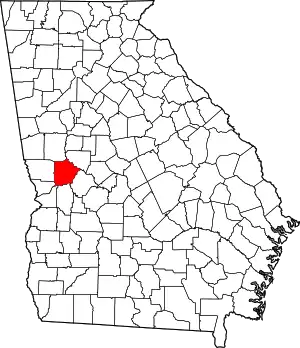 Map of Georgia highlighting Talbot County | |
| Towns | ||
| CDP | ||
| Other unincorporated communities | ||
| Footnotes | ‡This populated place also has portions in an adjacent county or counties | |