Königsberg in Bayern | |
|---|---|
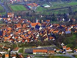 Aerial view of the old town of Königsberg | |
 Coat of arms | |
Location of Königsberg in Bayern within Haßberge district  | |
 Königsberg in Bayern 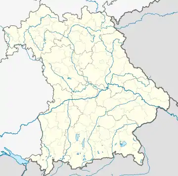 Königsberg in Bayern | |
| Coordinates: 50°4′40″N 10°34′00″E / 50.07778°N 10.56667°E | |
| Country | Germany |
| State | Bavaria |
| Admin. region | Unterfranken |
| District | Haßberge |
| Subdivisions | 10 Ortsteile |
| Government | |
| • Mayor (2020–26) | Claus Bittenbrünn[1] (CSU) |
| Area | |
| • Total | 61.86 km2 (23.88 sq mi) |
| Elevation | 280 m (920 ft) |
| Population (2022-12-31)[2] | |
| • Total | 3,624 |
| • Density | 59/km2 (150/sq mi) |
| Time zone | UTC+01:00 (CET) |
| • Summer (DST) | UTC+02:00 (CEST) |
| Postal codes | 97486 |
| Dialling codes | 09525 |
| Vehicle registration | HAS |
| Website | www.koenigsberg.de |
Königsberg in Bayern is a town in the Haßberge district, in Lower Franconia, Bavaria, Germany. It is situated 7 km (5 miles) northeast of Haßfurt, and 31 km (20 miles) northwest of Bamberg.
It was an exclave of Saxe-Coburg and Gotha until 1918, after having been a part of Saxe-Hildburghausen.
Notable people

Plaque at the birthplace of Regiomontanus
- Johannes Müller alias Regiomontanus (1436-1476), a famous mathematician and astronomer.[3]
- Johannes Marcellus (1510-1552), a philologist and poet, also called Regiomontanus
- Wolfgang Carl Briegel (1626–1712) a German organist, teacher, and composer.
- Friedrich Heinrich von Seckendorff (1673–1763), Imperial Fieldmarschall and diplomat.[4]
References
- ↑ Liste der ersten Bürgermeister/Oberbürgermeister in kreisangehörigen Gemeinden, Bayerisches Landesamt für Statistik, 15 July 2021.
- ↑ Genesis Online-Datenbank des Bayerischen Landesamtes für Statistik Tabelle 12411-003r Fortschreibung des Bevölkerungsstandes: Gemeinden, Stichtag (Einwohnerzahlen auf Grundlage des Zensus 2011)
- ↑ Clerke, Agnes Mary (1911). . Encyclopædia Britannica. Vol. 23 (11th ed.). p. 39.
- ↑ . Encyclopædia Britannica. Vol. 24 (11th ed.). 1911. p. 469.
Towns and municipalities in Haßberge (district) | ||
|---|---|---|
Coat of Arms of Haßberge district | ||
This article is issued from Wikipedia. The text is licensed under Creative Commons - Attribution - Sharealike. Additional terms may apply for the media files.