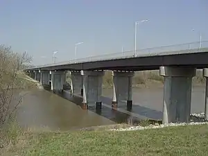
K-32 Turner Bridge | |
|---|---|
 The new bridge in 2007 | |
| Coordinates | 39°05′36″N 94°42′36″W / 39.0934°N 94.7100°W |
| Carries | 5 lanes of |
| Crosses | Kansas River |
| Locale | Kansas City, Kansas |
| Official name | Turner Diagonal Memorial Bridge |
| Maintained by | KDOT |
| Characteristics | |
| Design | Thru-Truss (first bridge), Girder (second and current bridge) |
| History | |
| Opened | 1955 (first bridge), 2002 (second and current bridge) |
| Location | |
The K-32 Turner Bridge was a bridge that crossed the Kansas River during its almost 60 mile journey through Kansas City, and Topeka. It first opened in 1955 as a two lane steel through-truss bridge. In 2001, the bridge was torn down, due to its major superstructure problems, and with the growing area, could no longer handle the traffic flow as a two lane. By late 2002, the through-truss was gone, and a new five lane girder was in place. The bridge now carries two lanes of eastbound traffic, and three lanes westbound. The Turner Bridge marks the beginning of the Turner Diagonal.[1]
The first bridge in the area called the "Turner Bridge" was designed and announced in 1898. The first bridge was a steel bridge with three spans and had an estimated cost of $60,000 to build.[2]
There is as boat ramp located at the bridge site.[3] The ramp is located at river mile 9.2 of the Kansas River, gps N39.093 W94.711.[4]
References
- ↑ "Latitude and longitude of Turner Bridge". Latitutde. Retrieved December 28, 2018.
- ↑ "1st Turner Bridge built in Turner, KS". Kansas City Gazette. June 25, 1893. p. 8. Retrieved December 28, 2018.
- ↑ Cronkleton, Robert (May 22, 2018). "Rescuers search Kansas River for possible victim after submerged boat found". Kansas City Star. Retrieved November 6, 2018.
- ↑ "River Mile 9 – Turner Bridge Access Ramp". Friends of the Kaw. Retrieved December 28, 2018.