| National Highway 8 | |
|---|---|
| Kabul–Jalalabad Road | |
| Location | |
| Country | Afghanistan |
| Highway system | |
.jpg.webp)
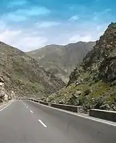
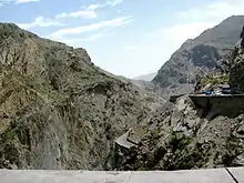
The Kabul–Jalalabad Road, also known as National Highway 08 (NH08), is a highway running between the Afghan cities of Kabul (the national capital) and Jalalabad, the largest city in eastern Afghanistan and capital of Nangarhar Province.[1] A portion of the road runs through the Tang-e Gharu gorge.[2]
The road is about 152 kilometres (94 mi) long and travels upwards from an elevation of 575 m in Jalalabad to 1790 m in Kabul.[3] Because of the many traffic accidents, the road between Jalalabad and Kabul is considered to be one of the most dangerous in the world.[4][5] It consists of narrow roads with sharp turns past high cliffs and a valley of the Kabul River below, with which it runs parallel.[6]
It is a large part of the Afghan leg of the Grand Trunk Road. Parts of the road follow the British Army's disastrous 1842 retreat from Kabul.
See also
References
- ↑ "Application of Road Numbering System National Highway", Archived 2017-05-07 at the Wayback Machine The Ministry of Public Works (October 16, 2015)
- ↑ Gladstone, Cary (2001). Afghanistan Revisited. Nova Publishers. ISBN 9781590334218.
- ↑ https://www.adb.org/sites/default/files/project-document/61388/44482-01-afg-iee-02.pdf
- ↑ "The Most Dangerous Road?"
- ↑ "On Afghan Road, Scenes of Beauty and Death"
- ↑ "Are you brave enough to tackle the Kabul-Jalalabad Highway?". 15 August 2018.
| Districts |  | |
|---|---|---|
| Populated places | ||
| Buildings and structures |
| |
| Other | ||