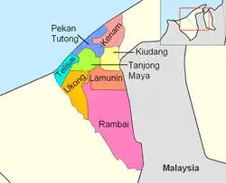
Mukim Lamunin | |
|---|---|
 Lamunin is in peach. | |
| Coordinates: 4°41′22″N 114°40′39″E / 4.689522°N 114.677424°E | |
| Country | Brunei |
| District | Tutong |
| Population (2016)[1] | |
| • Total | 4,298 |
| Time zone | UTC+8 (BNT) |
| Postcode | TGxx43 |
Mukim Lamunin is a mukim in Tutong District, Brunei. The population was 4,298 in 2016.[1]
Name
The mukim could be named after a village it encompasses, Kampong Lamunin. Lat and Munin made up the word Lamunin. Evidently, Lat and Munin both refer to hills, or musang (fox). Since foxes once roamed the area, Lat Munin, the ancient name, means Fox's Hill or Hill of Foxes. The two names eventually fused to form Lamunin, hiding both their animal origin and link.[2]
Geography
The mukim is located in the east and centre of the Tutong District, bordering Mukim Kiudang to the north, the Limbang District in the Malaysian state of Sarawak to the east, Mukim Rambai to the south and south-west, Mukim Ukong to the west and Mukim Tanjong Maya to north-west.
The mukim is named after Kampong Lamunin, one of the villages it encompasses.
Demographics
As of 2016 census,[1] the population was 4,298 with 51.2% males and 48.8% females. The mukim had 770 households occupying 760 dwellings. The entire population lived in rural areas.
Villages
As of 2016, the mukim comprised the following census villages:[1]
| Village | Population (2016) |
|---|---|
| Kampong Bintudoh | 332 |
| Kampong Biong | 263 |
| Kampong Bukit Bang Dalam | 199 |
| Kampong Bukit Barun | 275 |
| Kampong Bukit Sulang | 362 |
| Kampong Kuala Abang | 379 |
| Kampong Lamunin | 1,596 |
| Kampong Layong | 261 |
| Kampong Menengah[lower-alpha 1] | 183 |
| Kampong Panchong | 448 |
| Total | 4,298 |
Infrastructures
The local primary schools include Kampong Menengah Primary School, Lamunin Primary School and Panchong Primary School. Each of Kampong Menengah Primary School and Panchong Primary School also houses a sekolah ugama ("religious school" i.e. school for the country's Islamic religious primary education). Meanwhile, another sekolah ugama, namely Lamunin Religious School, has its own grounds.
The local mosques include:
- Kampong Bang Dalam Mosque — originally a balai ibadat ("prayer hall") which was built in 1988. A new mosque was built to replace the balai ibadat; it was opened for use on 5 January 2000.[3]
- Kampong Layong Mosque — inaugurated on 20 July 1990; it can accommodate 300 worshippers.[4]
- Kampong Menengah Mosque — inaugurated on 27 July 1990; it can accommodate 230 worshippers.[5]
Lamunin Health Centre (Pusat Kesihatan Lamunin) is the community health centre for the local residents as well as those in Mukim Rambai, Mukim Ukong, Mukim Kiudang and Mukim Tanjong Maya.[6]
Other local facilities include Lamunin Post Office, Lamunin Police Station and Lamunin Fire Station.
Notable people
Notes
- ↑ Not to be confused with the village of the same name in Mukim Bangar, Temburong District
References
- 1 2 3 4 "Population and Housing Census Update Final Report 2016" (PDF). www.deps.gov.bn. Statistics Department. December 2018. Retrieved 27 June 2021.
- ↑ Mohd Yunos, Rozan (2013). SEMINAR UNITED NATIONS GROUP OF EXPERTS ON GEOGRAPHICAL NAMES ASIA, SOUTHEAST DIVISION (PDF). p. 17.
- ↑ "SenaraiMasjid - Masjid Kampong Bang Dalam". www.kheu.gov.bn (in Malay). Archived from the original on 26 May 2018. Retrieved 19 October 2021.
- ↑ "SenaraiMasjid - Masjid Kampong Layong". www.kheu.gov.bn (in Malay). Archived from the original on 19 October 2021. Retrieved 19 October 2021.
- ↑ "SenaraiMasjid - Masjid Kampong Menengah". www.kheu.gov.bn (in Malay). Archived from the original on 25 May 2018. Retrieved 19 October 2021.
- ↑ "Ministry of Health - Lamunin Health Centre". www.moh.gov.bn. Archived from the original on 4 February 2020. Retrieved 19 October 2021.
- ↑ "Keluaran Khas Sempena Pelantikan Menteri-Menteri Kabinet dan Timbalan-Timbalan Menteri" (PDF). Pelita Brunei. 12 June 2010. p. 7.