| Schmale Sinn | |
|---|---|
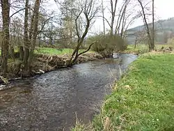
 The Schmale Sinn close to its confluence with the Sinn | |
| Location | |
| Country | Germany |
| States | Bavaria and Hesse |
| Physical characteristics | |
| Mouth | |
• location | Sinn |
• coordinates | 50°15′24″N 9°38′30″E / 50.2568°N 9.6416°E |
| Length | 32.4 km (20.1 mi) [1] |
| Basin size | 104 km2 (40 sq mi) [1] |
| Basin features | |
| Progression | Sinn→ Franconian Saale→ Main→ Rhine→ North Sea |
Schmale Sinn (in its upper course in Bavaria: Kleine Sinn) is a river of Bavaria and Hesse, Germany. It is a right tributary of the Sinn near Zeitlofs. Via the Franconian Saale it discharges into the Main.
See also
References
- 1 2 Complete table of the Bavarian Waterbody Register by the Bavarian State Office for the Environment (xls, 10.3 MB)
This article is issued from Wikipedia. The text is licensed under Creative Commons - Attribution - Sharealike. Additional terms may apply for the media files.