Klungkung Regency
Kabupaten Klungkungᬓᬩᬸᬧᬢᬾᬦ᭄ᬓ᭄ᬮᬸᬂᬓᬸᬂKabupatén Kluŋkuŋ | |
|---|---|
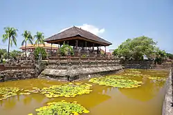
 Kerta Gosa | |
 Flag  Seal | |
| Motto: Dharmaning Ksatriya Mahottama | |
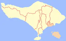
 Location within Bali | |
| Country | |
| Province | |
| Capital | Semarapura |
| Government | |
| • Regent | I Nyoman Suwirta |
| Area | |
| • Total | 121.62 sq mi (315.00 km2) |
| Population (2020 Census)[1] | |
| • Total | 206,925 |
| • Density | 1,700/sq mi (660/km2) |
| Time zone | UTC+8 (ICST) |
| Area code | (+62) 366 |
| Website | klungkungkab.go.id |
Klungkung Regency is the smallest regency (kabupaten) in the island province of Bali, Indonesia. It has an area of 315 km2 and had a population at the 2010 Census of 170,543[2] which increased to 206,925 at the Census of 2020;[3] the official estimate as at mid 2022 was 214,012 (comprising 107,177 males and 106,815 females).[1] The administrative centre for the regency (and for Klungkung District within the regency) is in the town of Semarapura.
Semarapura town is easily reached from Gianyar via the highway. The regency is famous for its classic Balinese paintings which mostly depict the story of epics such as Mahabharata or Ramayana. These classical style paintings come from the frescoes of the Balinese palaces and can also be found at Klungkung Palace in the downtown area. Semarajaya Museum is also located in the area.
Some 64.4% of the land area of Klungkung is made of the offshore islands of Nusa Penida, Nusa Ceningan, Nusa Lembongan and eleven smaller islands, which together form Nusa Penida District, of which the town of Sampalan is the administrative centre; the other three districts lie on the island of Bali itself, in its southeast corner.
History
Klungkung Regency is the successor of the Kingdom of Klungkung (Kloengkoeng in older spelling), one of several kingdoms on Bali that traces its founding to before European arrival in Southeast Asia. The realm, while small in comparison to its neighbors, is actually the most important one. Its rulers, titled Dewa Agung (lit. 'Great God'), are long considered by other lords as high king of Bali with both spiritual and temporal powers.
The royal house of Klungkung is direct descendant of the kings of Gelgel, a kingdom which ruled over the entire island, first as vassal kingdom of Majapahit, and later as an independent kingdom with influence over eastern Java and nearby Nusa Penida, Lombok, and Sumbawa. According to Babad Dalem, a breakdown in royal authority following a palace coup sometimes in the 16th century resulted in regional lords attaining greater autonomy. While the royal family managed to resumed control in Klungkung, they were in no position to assert any lost authority over the now-independent rajahs. However, the rajah of Klungkung is still considered senior in rank to other rajahs.
The arrival of European ships on Balinese ports introduced the isolated island to global trade. Especially the Dutch, missions to establish economic relations soon turn into military colonial expeditions:
- First Dutch Punitive Expedition in Northern Bali (1846);
- Second Dutch Punitive Expedition in Northern Bali (1848);
- Dutch Intervention in Buleleng, Karangasem, and Klungkung (1849);
- Dutch Intervention in Bali (1858);
- Dutch Intervention in Lombok War (1894);
- Dutch Conquest of Badung and Tabanan (1906); and
- Dutch Conquest of Klungkung (1908).
Following the fall of Klungkung as the last independent native realm on Bali, Dutch colonial administration either ruled the island indirectly (rulers of Karangasem and Gianyar as stedehouder, "viceroy") or directly administered public administration in the absence of local rulers. However in 1920s, living relatives of former royal houses deemed acceptable by the Dutch were appointed as regents in their fallen realms. By 1938, Paruman Agung, a council of rajahs of Bali was established, and the regents and viceroys were consecrated as kings (including Klungkung) reestablishing the kingdoms as "self-governing realms" within the Netherlands East Indies.
This system of self-rule was maintained somewhat during Japanese occupation of the colony, though the occupying Japanese force intervened in various kingdoms, forcefully deposing local rulers. In 1946, Dutch colonial administration returned to the island, and began to introduce Bali rulers to the idea of a federation of states in eastern Indonesia, in opposition to unitarian Indonesian Republic. By 1947, the State of East Indonesia was formed with Bali as a part of it. In 1949, the state became part of United States of Indonesia, and in less than a year, decided to merge into Republic of Indonesia. With it, the kingdom of Klungkung loses its sovereignty and transformed into the current Regency of Klungkung, a subdivision of the Province of Bali.
Currently, the regency is the smallest (excluding Denpasar, which is a city and smaller in size) and least populated in Bali, as well as least visited by tourists.[4]
Administrative Districts
The regency is divided into four districts (kecamatan), listed below with their areas and their populations at the 2010 Census[2] and the 2020 Census,[3] together with the official estimates as at mid 2022[1] and the population density in 2022. The table also includes the locations of the district administrative centres, the number of administrative villages in each district (totaling 53 rural desa and 6 urban kelurahan - the latter all in the Semarapura part of Klungkung District), and its postal codes.
| Kode Wilayah | Name of District (kecamatan) | Area in km2 | Pop'n Census 2010 | Pop'n Census 2020 | Pop'n Estimate mid 2022 | Density (per km2) in 2022 | Admin centre | No. of villages | Post codes |
|---|---|---|---|---|---|---|---|---|---|
| 51.05.01 | Nusa Penida | 202.84 | 45,110 | 57,370 | 59,900 | 295 | Sampalan | 16 | 80771 |
| 51.05.02 | Banjarangkan | 45.73 | 37,115 | 44,431 | 45,800 | 1,002 | Banjarangkan | 13 (a) | 80752 |
| 51.05.03 | Klungkung (district) | 29.05 | 55,141 | 64,235 | 65,900 | 2,269 | Semarapura | 18 | 80711 -80716 |
| 51.05.04 | Dawan | 37.38 | 33,177 | 40,889 | 42,400 | 1,135 | Dawan | 12 | 80761 |
| Totals | 315.00 | 170,543 | 206,925 | 214,012 | 679 | Semarapura | 59 |
Note: (a) including the 6 kelurahan of Semarapura Kaja, Semarapura Kangin, Semarapura Kauh, Semarapura Klod, Semarapura Klod Kangin and Semarapura Tengah.
 Japanese army Shelters, Banjarangkan, Klungkung
References
- 1 2 3 Badan Pusat Statistik, Jakarta, 2023, Kabupaten Klungkung Dalam Angka 2023 (Katalog-BPS 1102001.5105)
- 1 2 Biro Pusat Statistik, Jakarta, 2011.
- 1 2 Badan Pusat Statistik, Jakarta, 2021.
- ↑ "Sepi DuaTahun, Kerta Gosa Klungkung Akhirnya Dikunjungi Rombongan Wisatawan Asing". Tribun-bali.com (in Indonesian). Retrieved 2023-08-19.
External links
 Klungkung Regency travel guide from Wikivoyage
 Media related to Klungkung at Wikimedia Commons
- (in Indonesian) Official website
8°32′20.12″S 115°24′16.24″E / 8.5389222°S 115.4045111°E