.jpg.webp) | |
| Location | City of Brussels, Brussels-Capital Region, Belgium |
| Coordinates | 50°50′38″N 04°21′24″E / 50.84389°N 4.35667°E |
| Built | 1954–1969 |
| Architect | Maurice Houyoux, Jules Ghobert René Péchère (garden) |
| Architectural style(s) | Modernism |
| Website | Official website |
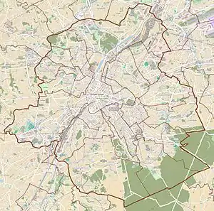 Location within Brussels  Mont des Arts (Belgium) | |
The Mont des Arts (French, pronounced [mɔ̃dɛzaʁ]) or Kunstberg (Dutch, pronounced [ˈkʏnzdbɛr(ə)x] ⓘ), meaning "Hill/Mount of the Arts", is an urban complex and historic site in central Brussels, Belgium, including the Royal Library of Belgium (KBR), the National Archives of Belgium, the Square – Brussels Meeting Centre, and a public garden.
This site is located between the Rue Montagne de la Cour/Hofbergstraat and the Place Royale/Koningsplein in its "upper" part, and the Boulevard de l'Empereur/Keizerslaan and the Place de l'Albertine/Albertinaplein in its "lower" part. It is served by Brussels-Central railway station.
History
Early history
The area of the Mont des Arts knew different affectations during its history. Jews settled there until the 14th century, as attested by the old Escaliers des Juifs or Ioode trappen ("Jewish Stairs"), a former series of four steep staircases leading to Brussels' upper town.[1] Later, it used to be a densely populated neighbourhood, the Saint-Roch Quarter (French: Quartier Saint-Roch, Dutch: Sint-Rochuswijk), centred around the now-disappeared Rue des Trois-Têtes/Driehoofdenstraat[2] and the former Place du Palais/Paleisplein (today's Place de la Justice/Gerechtsplein), where Brussels' first courthouse was located.[3]
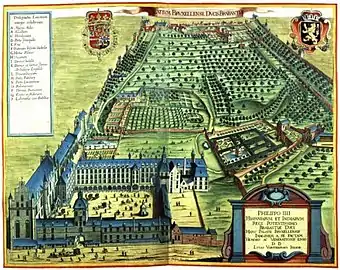
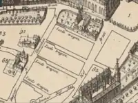
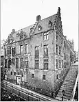
Between the 15th and the 18th centuries, the hill overlooking the neighbourhood was known as the Montagne de la Cour/Hofberg ("Hill/Mount of the Court") after the former Palace of Coudenberg also located there. This palace, famous all over Europe, had greatly expanded since it had first become the seat of the Dukes of Brabant, but it was destroyed by fire in 1731.[4] Only a small section of the Rue Montagne de la Cour now remains below the Place Royale/Koningsplein.[5] The district's development over the next centuries raised one of the most complex questions in the town-planning history of Brussels: the link between the upper and the lower town through the reorganisation of the Montagne de la Cour.[6]
First Mont des Arts (1910–1954)
By the end of the 19th century, King Leopold II had the idea to convert the site into an arts' quarter and bought the whole neighbourhood. Various architects and urban planners were called upon to draw plans of the buildings, which were to accommodate all kinds of cultural institutions.[7] In the meantime, the City of Brussels' then-mayor, Charles Buls, had laid out a modest plan for the Saint-Roch district. His urbanistic and aesthetic conceptions were totally opposed to those of Leopold II. The burgomaster wanted to preserve as much as possible of the old district, whilst the king imagined grandiose projects for his capital. Very isolated, Buls was not followed by the municipal council, which voted for the king's project on 19 November 1894. Sickened, Buls resigned five years later.[8][6]
After the demolition of the old buildings in 1897–98, the site turned into an urban void because the project lacked sufficient finance. An agreement was finally signed in 1903 between the City of Brussels and the Belgian State for the construction of the Central Station and the creation of the Mont des Arts, at the same time as the complete reorganisation of the old Saint-Roch and Putterie/Putterij districts. To increase the area's appeal during the Brussels International Exposition of 1910, the king ordered the French landscape architect Pierre Vacherot to design a "temporary" garden on the hill. It featured a park and a monumental staircase with cascading fountains and terraces descending the gentle slope from the Place Royale down to the Boulevard de l'Empereur/Keizerslaan.[5] In 1910, a year after the death of Leopold II, the new park was inaugurated by his successor, King Albert I.
_1898.jpg.webp) Destruction of the Saint-Roch Quarter in 1897–98 to make space for the Mont des Arts/Kunstberg
Destruction of the Saint-Roch Quarter in 1897–98 to make space for the Mont des Arts/Kunstberg The Mont des Arts in the 1920s showing Vacherot's temporary garden
Second Mont des Arts (1954–present)
Although the garden was conceived as temporary, it became a well-appreciated green area in the heart of the capital, but when the plans for the Mont des Arts came back by the end of the 1930s, it had to be demolished to create a new square as the centre of the urban renewal project. The project was entrusted jointly to the architects Maurice Houyoux and Jules Ghobert. Between 1956 and 1969, the park and its surroundings gave way to massive, severe geometric structures such as the Royal Library of Belgium (KBR) and the Congress Palace (now the Square – Brussels Meeting Centre). The new geometric garden, designed by the landscape architect René Pechère, was built upon the concrete slab covering the Albertine car park.[5] The construction of the Royal Library led to the complete disappearance of the old Palace of Orange-Nassau, with the exception of Saint George's Chapel. Faced with a wave of protests, it was decided in 1961–62 to integrate it into the library complex.[9] The inauguration took place in 1969.[6]
Present day
The Mont des Arts offers one of Brussels' finest views. Though the glass and steel cube forming the new entrance to the convention centre has modified the upper part of the complex, the perspective created by Péchère has largely been preserved. From the elevated vantage point, the famous tower of Brussels' Town Hall on the Grand-Place/Grote Markt is clearly visible.[10] On a sunny day, the Koekelberg Basilica and even the Atomium can be seen.[11] To the west rises the bronze Equestrian Statue of Albert I by the sculptor Alfred Courtens, inaugurated in 1951.[6] From the other end, looking up towards the Place Royale/Koningsplein, the dome of the Church of St. James on Coudenberg closes the perspective.
Major tourist attractions are located within walking distance of the Mont des Arts: the Musical Instruments Museum (MIM), the Royal Museums of Fine Arts, the Royal Palace, and the Cathedral of St. Michael and St. Gudula.
 The Royal Library of Belgium (KBR) and the Equestrian Statue of Albert I
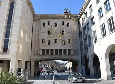 The Mont des Arts carillon
 The garden of the Mont des Arts during the day
.jpg.webp) The same view during nautical twilight
The same view during nautical twilight
See also
References
Citations
- ↑ "Localisation de 'Escalier des Juifs' sur 14 plans de Bruxelles". www.reflexcity.net. Retrieved 29 October 2021.
- ↑ "Localisation de 'Rue des Trois-Têtes' sur 14 plans de Bruxelles". www.reflexcity.net. Retrieved 29 October 2021.
- ↑ "Place de la Justice". www.reflexcity.net. Retrieved 29 October 2021.
- ↑ Anagnostopoulos & Houssiau 2006, p. 3.
- 1 2 3 "Kunstberg - History". www.montdesarts.com. Retrieved 9 June 2018.
- 1 2 3 4 "Mont des Arts – Inventaire du patrimoine architectural". monument.heritage.brussels (in French). Retrieved 29 October 2021.
- ↑ Liane Ranieri, Léopold II urbaniste, Brussels, Hayez (in French) (1973), p. 285
- ↑ Demey 1990, p. 260.
- ↑ Wasseige 1995, p. 26.
- ↑ "Mont des Arts Gardens". visit.brussels. Retrieved 9 June 2018.
- ↑ Poel, Nana Van De. "The History of the Mont des Arts in 1 Minute". Culture Trip. Retrieved 15 August 2018.
Bibliography
- Anagnostopoulos, Pierre; Houssiau, Jean (2006). The old palace of Coudenberg. Brussels, city of Art and History. Vol. 42. Brussels: Éditions de la Région de Bruxelles-Capitale. ISBN 978-2-93045-706-2.
- Demey, Thierry (1990). Bruxelles, chronique d’une capitale en chantier (in French). Vol. I: Du voûtement de la Senne à la jonction Nord-Midi. Brussels: Paul Legrain/CFC. OCLC 44643865.
- Wasseige, Manoëlle (1995). Le Quartier Royal. Bruxelles, ville d'Art et d'Histoire (in French). Vol. 15. Brussels: Éditions de la Région de Bruxelles-Capitale.
External links
 Media related to Kunstberg/Mont des Arts at Wikimedia Commons
- The Mont des Arts at the Brussels Tourist Board website