| Qvirila | |
|---|---|
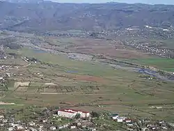
 The Qvirila near Sachkhere | |
 Qvirila  Qvirila (Imereti) | |
| Native name | ყვირილა (Georgian) |
| Location | |
| Country | Georgia |
| Physical characteristics | |
| Mouth | Rioni |
• coordinates | 42°10′21″N 42°43′43″E / 42.1724°N 42.7285°E |
| Length | 140 km (87 mi) |
| Basin size | 3,630 km2 (1,400 sq mi) |
| Basin features | |
| Progression | Rioni→ Black Sea |
| Tributaries | |
| • right | Dzirula |
The Qvirila (Georgian: ყვირილა) is a river of Georgia. It is 140 km (87 mi) long, and has a drainage basin of 3,630 km2 (1,400 sq mi).[1] It is a left affluent of the Rioni, which it joins south of the city Kutaisi.
Geographic information
It originates in South Ossetia, in the gorges of the mountains of the Racha Range. Most of the river is located in Georgia. After the confluence with its left tributary Dzirula it flows through flat terrain, before - through the mountains. The river is fed mainly by rain. On average, water flow per year near the city Zestafoni, located 42 kilometers from its mouth, 61 m³ / s, at the mouth of about 90 m³ /from. The river is suitable for whitewater canoeing.
The Chiatura manganese ore deposit is located in the river basin.[2][3]
References
Wikimedia Commons has media related to Qvirila.
- ↑ Statistical Yearbook of Georgia: 2020, National Statistics Office of Georgia, Tbilisi, 2020, p. 12.
- ↑ Qvirila, Georgia Mindat.org
- ↑ Chiat'ura Mn deposit (Chiaturskoe Mn deposit), Chiat'ura, Imereti, Georgia Mindat.org
This article is issued from Wikipedia. The text is licensed under Creative Commons - Attribution - Sharealike. Additional terms may apply for the media files.