Lidköping Municipality
Lidköpings kommun | |
|---|---|
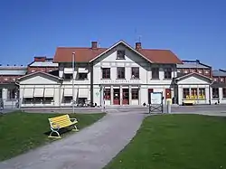
 Lidköping Railway Station | |
 Coat of arms | |
 | |
| Coordinates: 58°30′N 13°11′E / 58.500°N 13.183°E | |
| Country | Sweden |
| County | Västra Götaland County |
| Seat | Lidköping |
| Area | |
| • Total | 1,372.605625 km2 (529.965995 sq mi) |
| • Land | 695.605625 km2 (268.574833 sq mi) |
| • Water | 677 km2 (261 sq mi) |
| Area as of 1 January 2014. | |
| Population (31 December 2021)[2] | |
| • Total | 40,460 |
| • Density | 29/km2 (76/sq mi) |
| Time zone | UTC+1 (CET) |
| • Summer (DST) | UTC+2 (CEST) |
| ISO 3166 code | SE |
| Province | Västergötland |
| Municipal code | 1494 |
| Website | www.lidkoping.se |
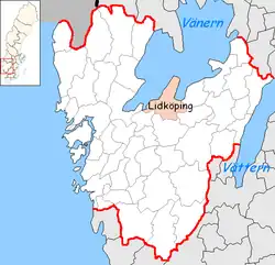
Lidköping Municipality (Lidköpings kommun) is a municipality in Västra Götaland County in western Sweden. Its seat is located in the city of Lidköping.
Lidköping sometimes refers to itself as "Lidköping by Vänern", possibly to distinguish itself from the namewise (and historically) similar city of Linköping in eastern Sweden.
Geography

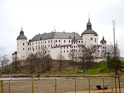
Lidköping Municipality is, together with its western neighbor Götene, located on the Läckö-Kinnekulla peninsula. There are several Vänern islands that belong to the municipality. One of them is Läckö, where the Läckö Castle is a notable sight.
Localities
Population numbers of the towns and villages, from SCB, December 31 of noted year.
| Year | 2002 | 2003 | 2004 | 2005 | 2010 |
|---|---|---|---|---|---|
| Lidköping | 24,679 | 24,885 | 24,960 | 24,941 | 25,644 |
| Vinninga | 1,079 | 1,060 | 1,054 | 1,064 | 1,078 |
| Järpås | 865 | 868 | 876 | 808 | 795 |
| Filsbäck | 656 | 656 | 652 | 647 | 615 |
| Örslösa | 308 | 305 | 310 | 298 | 307 |
| Saleby | 219 | 218 | 217 | 213 | 232 |
| Tun | 219 | 210 | 208 | 207 | 206 |
Demographics
This is a demographic table based on Lidköping Municipality's electoral districts in the 2022 Swedish general election sourced from SVT's election platform, in turn taken from SCB official statistics.[3]
Residents include everyone registered as living in the district, regardless of age or citizenship status. Valid voters indicate Swedish citizens above the age of 18 who therefore can vote in general elections. Left vote and right vote indicate the result between the two major blocs in said district in the 2022 general election. Employment indicates the share of people between the ages of 20 and 64 who are working taxpayers. Foreign background is defined as residents either born abroad or with two parents born outside of Sweden. Median income is the received monthly income through either employment, capital gains or social grants for the median adult above 20, also including pensioners in Swedish kronor. The section about college graduates indicates any degree accumulated after high school.
In total there were 40,403 residents, including 31,517 Swedish citizens of voting age.[3] 49.3 % voted for the left coalition and 49.5 % for the right coalition.
| Location | Residents | Valid voters | Left vote | Right vote | Employed | SV parents | 1st/2nd gen | Income | College |
|---|---|---|---|---|---|---|---|---|---|
| % | % | % | % | % | % | ||||
| Dalängen | 2,047 | 1,477 | 57.5 | 40.9 | 80 | 79 | 21 | 26,421 | 43 |
| Framnäs | 1,743 | 1,356 | 57.4 | 40.5 | 72 | 71 | 29 | 21,445 | 32 |
| Fredriksdal | 1,771 | 1,388 | 51.1 | 47.4 | 76 | 70 | 30 | 22,875 | 28 |
| Gamla stadens C | 1,793 | 1,496 | 47.4 | 50.7 | 77 | 74 | 26 | 24,133 | 34 |
| Hovby-Majåker | 2,062 | 1,571 | 53.9 | 45.6 | 91 | 93 | 7 | 29,771 | 50 |
| Järpås | 1,326 | 1,027 | 42.1 | 57.3 | 80 | 90 | 10 | 25,426 | 23 |
| Lidåker-Ljunghed | 1,819 | 1,467 | 54.0 | 44.5 | 86 | 87 | 13 | 25,252 | 36 |
| Margretelund N | 1,813 | 1,346 | 49.9 | 47.5 | 67 | 61 | 39 | 20,152 | 24 |
| Margretelund S | 1,853 | 1,387 | 56.2 | 42.5 | 73 | 73 | 27 | 24,352 | 29 |
| Nya staden N | 1,779 | 1,482 | 53.9 | 45.1 | 79 | 83 | 17 | 24,443 | 41 |
| Nya staden S | 1,932 | 1,601 | 52.1 | 46.4 | 75 | 82 | 18 | 24,811 | 44 |
| Otterstad | 1,717 | 1,418 | 39.5 | 59.1 | 86 | 95 | 5 | 26,322 | 37 |
| Råda | 2,199 | 1,604 | 48.2 | 51.4 | 90 | 93 | 7 | 29,656 | 54 |
| Saleby-N Härene | 1,975 | 1,542 | 46.8 | 52.6 | 91 | 93 | 7 | 29,138 | 45 |
| Stenhammar | 2,196 | 1,650 | 45.8 | 53.6 | 90 | 95 | 5 | 31,474 | 57 |
| Sunnersberg | 1,975 | 1,468 | 46.8 | 52.6 | 91 | 93 | 7 | 29,138 | 45 |
| Tofta-Ulriksdal | 1,534 | 1,209 | 50.1 | 49.2 | 90 | 96 | 4 | 29,816 | 49 |
| Tun-Gillstad | 1,591 | 1,279 | 45.2 | 54.0 | 84 | 95 | 5 | 26,318 | 38 |
| Vinninga-Filsbäck | 2,121 | 1,641 | 46.0 | 52.8 | 87 | 93 | 7 | 27,933 | 37 |
| Wennerberg | 1,500 | 1,192 | 55.1 | 43.2 | 82 | 76 | 24 | 25,156 | 38 |
| Ågårdsområdet | 2,059 | 1,663 | 49.7 | 49.3 | 84 | 89 | 11 | 27,818 | 46 |
| Örslösa | 1,598 | 1,253 | 47.4 | 51.8 | 88 | 95 | 5 | 26,472 | 35 |
| Source: SVT[3] | |||||||||
Symbol
Lidköping is developing a profile plan to market itself as "Lidköping by Vänern" and to this end have established the use of a logo depicting its location by Vänern. This logo is used in all official contexts, and also on the road signs when entering Lidköping.
See also
- Köping (concept)
References
- ↑ "Statistiska centralbyrån, Kommunarealer den 1 januari 2014" (in Swedish). Statistics Sweden. 2014-01-01. Archived from the original (Microsoft Excel) on 2016-09-27. Retrieved 2014-04-18.
- ↑ "Folkmängd i riket, län och kommuner 31 december 2021" (in Swedish). Statistics Sweden. February 22, 2022. Retrieved February 22, 2022.
- 1 2 3 "Valresultat 2022 för Lidköping i riksdagsvalet" (in Swedish). SVT. 11 September 2022. Retrieved 8 January 2024.
External links
- Lidköping Municipality - Official site
- Läckö Kinnekulle - The "Götene-Lidköping Vänern" tourism company
- (in Swedish) Article Lidköping - From Nordisk Familjebok (vol. 16, 1912)
- (in Swedish) Lidköpings kommun profilprogram.pdf Lidköping describes its symbol and its uses. In Swedish only.