L'Huisserie | |
|---|---|
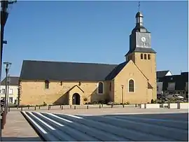 The church of Saint Siméon, in L'Huisserie | |
Location of L'Huisserie | |
 L'Huisserie  L'Huisserie | |
| Coordinates: 48°01′29″N 0°46′03″W / 48.0247°N 0.7675°W | |
| Country | France |
| Region | Pays de la Loire |
| Department | Mayenne |
| Arrondissement | Laval |
| Canton | L'Huisserie |
| Intercommunality | Laval Agglomération |
| Government | |
| • Mayor (2020–2026) | Jean-Pierre Thiot[1] |
| Area 1 | 14.72 km2 (5.68 sq mi) |
| Population | 4,435 |
| • Density | 300/km2 (780/sq mi) |
| Time zone | UTC+01:00 (CET) |
| • Summer (DST) | UTC+02:00 (CEST) |
| INSEE/Postal code | 53119 /53970 |
| Elevation | 37–118 m (121–387 ft) |
| 1 French Land Register data, which excludes lakes, ponds, glaciers > 1 km2 (0.386 sq mi or 247 acres) and river estuaries. | |
L'Huisserie (French pronunciation: [lɥisʁi]) is a commune in the Mayenne department in north-western France.
It boards the Jouanne river.
Population
| Year | Pop. | ±% p.a. |
|---|---|---|
| 1968 | 812 | — |
| 1975 | 1,651 | +10.67% |
| 1982 | 2,290 | +4.78% |
| 1990 | 2,863 | +2.83% |
| 1999 | 3,592 | +2.55% |
| 2007 | 3,901 | +1.04% |
| 2012 | 4,161 | +1.30% |
| 2017 | 4,244 | +0.40% |
| Source: INSEE[3] | ||
Gallery
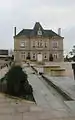 Town Hall
See also
References
- ↑ "Répertoire national des élus: les maires" (in French). data.gouv.fr, Plateforme ouverte des données publiques françaises. 13 September 2022.
- ↑ "Populations légales 2021". The National Institute of Statistics and Economic Studies. 28 December 2023.
- ↑ Population en historique depuis 1968, INSEE
Wikimedia Commons has media related to L'Huisserie.
This article is issued from Wikipedia. The text is licensed under Creative Commons - Attribution - Sharealike. Additional terms may apply for the media files.