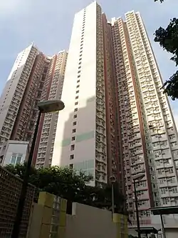
| Wah Lai Estate | |
|---|---|
 Wah Lai Estate | |
| General information | |
| Location | 282 Lai King Hill Road, Lai Chi Kok Kowloon, Hong Kong |
| Coordinates | 22°20′33″N 114°08′15″E / 22.342525°N 114.137542°E |
| Status | Completed |
| Category | Public rental housing |
| Population | 5,711[1] (2016) |
| No. of blocks | 2[2] |
| No. of units | 1,517[2] |
| Construction | |
| Constructed | 2001 |
| Authority | Hong Kong Housing Authority |
Wah Lai Estate (Chinese: 華荔邨) is a public housing estate in Lai Chi Kok, Kowloon, Hong Kong. It consists of a total of two residential blocks completed in 2001.[2]
Lai Yan Court (荔欣苑) is a Home Ownership Scheme housing court in Lai Chi Kok near Wah Lai Estate and within walking distance to Mei Foo station.[3] Together with Wah Lai Estate and Nob Hill, it was formerly the site of Lai Chi Kok Amusement Park. It has three residential blocks completed in 2001.[4]
Background
Although it administratively belongs to Kwai Tsing District, it is very near Mei Foo Sun Chuen, Lai Chi Kok rather than other parts in Kwai Chung. Sham Shui Po District Council requested the government to include the estate into its district, but there are still no changes in the boundary related to the estate.[5][6] However, the government decided to include the entire Nob Hill, a private housing estate next to Wah Lai Estate, into Sham Shui Po District in 2007.[7]
Houses
Wah Lai Estate
| Name[2] | Chinese name | Building type | Completed |
|---|---|---|---|
| Hei Lai House | 喜荔樓 | Harmony 1 | 2001 |
| Seung Lai House | 賞荔樓 |
Lai Yan Court
| Name[4] | Chinese name | Building type | Completed |
|---|---|---|---|
| Lai Ying House | 荔影閣 | Harmony 1 | 2001 |
| Lai Choi House | 荔采閣 | ||
| Lai Lam House | 荔林閣 |
Demographics
According to the 2016 by-census, Wah Lai Estate had a population of 5,711 while Lai Yan Court had a population of 5,562. Altogether the population amounts to 11,273.[1]
Politics
Wah Lai Estate and Lai Yan Court are located in Lai Wah constituency of the Kwai Tsing District Council.[8] It was formerly represented by Steve Cheung Kwan-kiu, who was elected in the 2019 elections until July 2021.[9]
See also
References
- 1 2 "Major Housing Estates". 2016 Population By-census. Census and Statistics Department. Retrieved 11 August 2021.
- 1 2 3 4 "Housing Authority Property Location and Profile | Hong Kong Housing Authority and Housing Department | Hong Kong Housing Authority and Housing Department". Hong Kong Housing Authority. Retrieved 11 August 2021.
- ↑ "Mei Foo Station street map" (PDF). MTR Corporation. Retrieved 11 August 2021.
- 1 2 "Housing Authority Property Location and Profile | Hong Kong Housing Authority and Housing Department | Hong Kong Housing Authority and Housing Department". Hong Kong Housing Authority. Retrieved 11 August 2021.
- ↑ "Archived copy". Archived from the original on 10 June 2011. Retrieved 11 August 2021.
{{cite web}}: CS1 maint: archived copy as title (link) - ↑ "Archived copy". Archived from the original on 10 June 2011. Retrieved 11 August 2021.
{{cite web}}: CS1 maint: archived copy as title (link) - ↑ "Speech by SHA in moving resolution on District Councils Ordinance" (PDF). Home Affairs Bureau. Retrieved 11 August 2021.
- ↑ "Recommended District Council Constituency Areas (Kwai Tsing District)" (PDF). Electoral Affairs Commission. Retrieved 11 August 2021.
- ↑ "Kwai Tsing District Council - Kwai Tsing DC Members". District Council. Retrieved 11 August 2021.