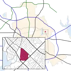
Lake Park Estates | |
|---|---|
 Location in Dallas | |
| Country | United States |
| State | Texas |
| Counties | Dallas |
| City | Dallas |
| Area | east Dallas |
| Elevation | 515 ft (157 m) |
| ZIP code | 75218 |
| Area code(s) | 214, 469, 972 |
| Website | http://www.lakeparkestates.org/ |
Lake Park Estates is a neighborhood in east Dallas, Texas (USA) on the north corner of the diagonal intersection of Buckner Road (Loop 12) and Garland Road (SH 78).[1] It is bordered by the Casa Linda Shopping Center, Casa Linda Estates, Old Lake Highlands, Eastwood, and Dallas's White Rock Lake Park.
About

Lake Park Estates contains 288 homes, most of which were built in the 1950s and 1960s. The neighborhood features variations on traditional ranch style houses, and it has some eclectic homes, including a notable home designed by Glenn Allen Galaway, a student of architect Philip Johnson.[2]
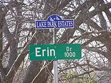
All but one of the streets in the neighborhood are named after Irish locations or themes: Donegal, County Cork, Waterford, Athlone, Kilarney, Tralee, Erin, Galway, Tipperary, Bridget, Limerick, and Wicklow. The sole exception is Tranquilla, which continues up from Casa Linda Estates, a neighborhood with Spanish-inspired street names.
The neighborhood is represented and served by the Lake Park Estates Neighborhood Association, a Texas nonprofit corporation.
Education
The neighborhood is served by the Dallas Independent School District. Children in the neighborhood attend Victor H. Hexter Elementary School, Robert T. Hill Middle School, and Bryan Adams High School.[3]
References
- ↑ Lake Highlands Area Improvement Association - Neighborhood & Homeowner Associations of Lake Highlands Archived 2006-06-20 at the Wayback Machine. (Note that Lake Park Estates does not consider itself a part of Lake Highlands.) Retrieved on 12 November 2006.
- ↑ Douglas Newby and Associates - Glenn Allen Galaway. Retrieved on 7 November 2006.
- ↑ Dallas ISD - 2007 School Feeder Patterns Archived 2007-05-31 at the Wayback Machine - Bryan Adams High School Archived 2008-05-17 at the Wayback Machine. (Maps: ES: Hexter Archived 2011-05-19 at the Wayback Machine; MS: Hill Archived 2007-06-16 at the Wayback Machine; HS: Adams Archived 2007-06-16 at the Wayback Machine.) Retrieved on 29 April 2007.
