Le Granit | |
|---|---|
 | |
| Coordinates: 45°35′N 70°53′W / 45.583°N 70.883°W[1] | |
| Country | |
| Province | |
| Region | Estrie |
| Effective | May 26, 1982 |
| County seat | Lac-Mégantic |
| Government | |
| • Type | Prefecture |
| • Prefect | Monique Pherivong Lenoir |
| Area | |
| • Total | 2,831.80 km2 (1,093.36 sq mi) |
| • Land | 2,735.21 km2 (1,056.07 sq mi) |
| Population (2016)[3] | |
| • Total | 21,462 |
| • Density | 7.8/km2 (20/sq mi) |
| • Change 2011-2016 | |
| • Dwellings | 12,478 |
| Time zone | UTC−5 (EST) |
| • Summer (DST) | UTC−4 (EDT) |
| Area code | 819 |
| Website | www |
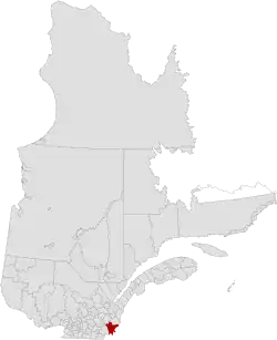
Le Granit (Granite) is a regional county municipality in the Estrie region of eastern Quebec, Canada. Located directly south of Quebec City, it borders the region of Chaudière-Appalaches, as well as the US states of New Hampshire and Maine. It is named for its abundance of granite. Created in 1982, Le Granit's seat is Lac-Mégantic.
Subdivisions
There are 20 subdivisions within the RCM:[2]
|
|
|
|
Demographics
Population
|
LanguageMother tongue (2016)[3]
|
Transportation
Access routes
Highways and numbered routes that run through the municipality, including external routes that start or finish at the county border:[6]
See also
References
- ↑ "Banque de noms de lieux du Québec: Reference number 141079". toponymie.gouv.qc.ca (in French). Commission de toponymie du Québec.
- 1 2 3 "Ministère des Affaires municipales, des Régions et de l'Occupation du territoire: Le Granit Regional County Municipality". Archived from the original on 2014-09-07. Retrieved 2012-03-11.
- 1 2 3 4 "Census Profile, 2016 Census: Le Granit, Municipalité régionale de comté [Census division], Quebec". Statistics Canada. Retrieved December 4, 2019.
- ↑ Statistics Canada: 1996, 2001, 2006, 2011 census
- ↑ 2011 Statistics Canada Census Profile: Le Granit Regional County Municipality, Quebec
- ↑ Official Transport Quebec Road Map
Adjacent Counties & Equivalent Territories | |
|---|---|
| Regional county municipalities and equivalent territories | |
|---|---|
| Municipalities | |
This article is issued from Wikipedia. The text is licensed under Creative Commons - Attribution - Sharealike. Additional terms may apply for the media files.