Le Haut-Richelieu Regional County Municipality | |
|---|---|
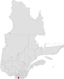 Location in province of Quebec. | |
| Coordinates: 45°12′N 73°14′W / 45.200°N 73.233°W[1] | |
| Country | |
| Province | |
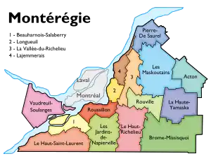
| Region | Montérégie |
| Effective | January 1, 1982 |
| County seat | Saint-Jean-sur-Richelieu |
| Government | |
| • Type | Prefecture |
| • Prefect | Gilles Dolbec |
| Area | |
| • Total | 999.70 km2 (385.99 sq mi) |
| • Land | 936.02 km2 (361.40 sq mi) |
| Population (2016)[3] | |
| • Total | 117,443 |
| • Density | 125.5/km2 (325/sq mi) |
| • Change 2011-2016 | |
| • Dwellings | 52,461 |
| Time zone | UTC−5 (EST) |
| • Summer (DST) | UTC−4 (EDT) |
| Area code(s) | 450 and 579 |
| Website | www |
Le-haut Richelieu is on the south border
Le Haut-Richelieu Regional County Municipality (Upper Richelieu) is a regional county municipality in the Montérégie region in southwestern Quebec, Canada. Its seat is in Saint-Jean-sur-Richelieu. It is named for the Richelieu River which runs south-north through it.
Subdivisions
There are 14 subdivisions within the RCM:[2]
|
|
|
Demographics
Population
Canada census – Le Haut-Richelieu community profile
| 2021 | 2016 | 2011 | |
|---|---|---|---|
| Population | 121,277 (+3.3% from 2016) | 117,443 (+2.7% from 2011) | 114,344 (+5.0% from 2006) |
| Land area | 934.85 km2 (360.95 sq mi) | 936.02 km2 (361.40 sq mi) | 936.26 km2 (361.49 sq mi) |
| Population density | 129.7/km2 (336/sq mi) | 125.5/km2 (325/sq mi) | 122.1/km2 (316/sq mi) |
| Median age | 44.0 (M: 42.8, F: 44.8) | 43.1 (M: 42.1, F: 44.1) | 41.6 (M: 40.7, F: 42.6) |
| Private dwellings | 55,208 (total) 52,723 (occupied) | 52,461 (total) | 50,665 (total) |
| Median household income | $75,500 | $61,778 | $55,167 |
|
|
| |||||||||||||||||||||||||||
| [9][3] | |||||||||||||||||||||||||||||
Language
| Canada Census Mother Tongue - Le Haut-Richelieu Regional County Municipality, Quebec[9] | ||||||||||||||||||
|---|---|---|---|---|---|---|---|---|---|---|---|---|---|---|---|---|---|---|
| Census | Total | French |
English |
French & English |
Other | |||||||||||||
| Year | Responses | Count | Trend | Pop % | Count | Trend | Pop % | Count | Trend | Pop % | Count | Trend | Pop % | |||||
2016 |
116,150 |
108,675 | 93.6% | 3,645 | 3.1% | 1,005 | 0.9% | 2,825 | 2.4% | |||||||||
2011 |
113,245 |
106,260 | 93.83% | 3,875 | 3.42% | 980 | 0.87% | 2,130 | 1.88% | |||||||||
2006 |
107,390 |
100,475 | 93.56% | 3,355 | 3.12% | 695 | 0.65% | 2,865 | 2.67% | |||||||||
2001 |
99,630 |
93,170 | 93.52% | 3,750 | 3.76% | 730 | 0.73% | 1,980 | 1.99% | |||||||||
1996 |
96,475 |
90,585 | n/a | 93.89% | 3,660 | n/a | 3.79% | 785 | n/a | 0.81% | 1,445 | n/a | 1.50% | |||||
Transportation
Access Routes
Highways and numbered routes that run through the municipality, including external routes that start or finish at the county border:[10]
See also
References
- ↑ "Banque de noms de lieux du Québec: Reference number 141078". toponymie.gouv.qc.ca (in French). Commission de toponymie du Québec.
- 1 2 "Répertoire des municipalités: Geographic code 560". www.mamh.gouv.qc.ca (in French). Ministère des Affaires municipales et de l'Habitation.
- 1 2 3 "Census Profile, 2016 Census; Le Haut-Richelieu, Municipalité régionale de comté [Census division], Quebec". Statistics Canada. Retrieved November 25, 2019.
- ↑ "2021 Community Profiles". 2021 Canadian Census. Statistics Canada. February 4, 2022. Retrieved 2023-10-19.
- ↑ "2016 Community Profiles". 2016 Canadian Census. Statistics Canada. August 12, 2021. Retrieved 2019-11-25.
- ↑ "2011 Community Profiles". 2011 Canadian Census. Statistics Canada. March 21, 2019. Retrieved 2014-02-08.
- ↑ "2006 Community Profiles". 2006 Canadian Census. Statistics Canada. August 20, 2019.
- ↑ "2001 Community Profiles". 2001 Canadian Census. Statistics Canada. July 18, 2021.
- 1 2 Statistics Canada: 1996, 2001, 2006, 2011 census
- ↑ Official Transport Quebec Road Map
Adjacent Counties & Equivalent Territories | |
|---|---|
This article is issued from Wikipedia. The text is licensed under Creative Commons - Attribution - Sharealike. Additional terms may apply for the media files.