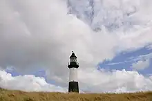
This is a list of lighthouses in Falkland Islands.[1][2]
Lighthouses
| Name | Image | Year built | Coordinates | Class of Light | Focal height | NGA number | Admiralty number | Range nml |
|---|---|---|---|---|---|---|---|---|
| Cape Pembroke Lighthouse |  | 1987 | 51°40′54.6″S 57°43′13.44″W / 51.681833°S 57.7204000°W | Fl (3) W 20s. | 30 metres (98 ft) | 20336 | G1352 | 10 |
| Fox Point Lighthouse | n/a | 51°55′18.7″S 58°24′10.1″W / 51.921861°S 58.402806°W | Fl (2) 10s. | 14 metres (46 ft) | 20353 | G1353 | 10 | |
| Kukri Point Lighthouse | n/a | 51°54′20.8″S 58°25′41.6″W / 51.905778°S 58.428222°W | Oc W 6s. | 8 metres (26 ft) | 20359.1 | G1356 | 7 | |
| Mare Harbor Lighthouse | n/a | 51°54′02.2″S 58°28′13.6″W / 51.900611°S 58.470444°W | Oc WRG 5s. | 20 metres (66 ft) | 20357 | G1354 | white:9 red: 6 green: 7 | |
| Mengeary Point Lighthouse | n/a | 51°38′46.0″S 57°43′49.3″W / 51.646111°S 57.730361°W | Fl (2) W 7s. | 7 metres (23 ft) | 20340 | G1342 | 10 | |
| Navy Point Lighthouse | n/a | 51°40′56.9″S 57°49′52.9″W / 51.682472°S 57.831361°W | Fl R 6s. | 5 metres (16 ft) | 20348 | G1346 | 2 | |
| Porpoise Point Lighthouse | 1990 | 52°20′33.6″S 59°18′37.0″W / 52.342667°S 59.310278°W | Fl W 10s. | n/a | 20361 | G1359 | 10 | |
| Providence Head Lighthouse | n/a | 51°54′40.1″S 58°26′24.5″W / 51.911139°S 58.440139°W | Fl WR 2s. | 8 metres (26 ft) | 20359 | G1355 | 6 | |
See also
References
- ↑ Rowlett, Russ. "Lighthouses of Falkland Islands". The Lighthouse Directory. University of North Carolina at Chapel Hill. Retrieved 18 September 2016.
- ↑ List of Lights, Buoys and Fog Signals. Retrieved 18 September 2016
External links
Wikimedia Commons has media related to Lighthouses in the Falkland Islands.
- Rowlett, Russ. "The Lighthouse Directory". University of North Carolina at Chapel Hill.
This article is issued from Wikipedia. The text is licensed under Creative Commons - Attribution - Sharealike. Additional terms may apply for the media files.
_-_cropped.jpg.webp)