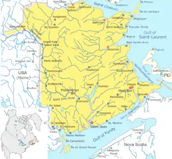
Map of New Brunswick showing the major streams and rivers
This is a List of bodies of water in the Canadian province of New Brunswick, including waterfalls.
New Brunswick receives precipitation year-round, which feeds numerous streams and rivers. There are two main discharge basins: the Gulf of Saint Lawrence to the east and north and the Bay of Fundy to the south. The major rivers are the Saint John River (Wolastoq) and the Miramichi River.
Bodies of water
- Bodies of water of New Brunswick
See also
References
External links
- "New Brunswick Watersheds". Environment and Local Government. Government of New Brunswick.
- "New Brunswick Watershed Groups and Provisional Water Classification". Watershed Caucus. New Brunswick Environmental Network.
- Map of New Brunswick Watershed Groups and Provisional Water Classification
- "Watersheds". Union of New Brunswick Indians.
- Map of the main rivers of New Brunswick in French
- "Rivers". The Atlas of Canada. Archived from the original on 20 May 2006.
Province of New Brunswick | ||
|---|---|---|
| Government and politics |
|  |
| Geography | ||
| Culture | ||
| Economy and Transportation |
| |
| History |
| |
| ||
This article is issued from Wikipedia. The text is licensed under Creative Commons - Attribution - Sharealike. Additional terms may apply for the media files.