Littleton–Mineral | |||||||||||||
|---|---|---|---|---|---|---|---|---|---|---|---|---|---|
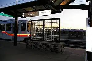
 D Line train entering station after turning back south of the station | |||||||||||||
| General information | |||||||||||||
| Other names | Littleton•Mineral | ||||||||||||
| Location | 3202 West Mineral Avenue Littleton, Colorado | ||||||||||||
| Coordinates | 39°34′48″N 105°01′30″W / 39.580127°N 105.024981°W | ||||||||||||
| Owned by | Regional Transportation District | ||||||||||||
| Line(s) | Southwest Corridor[1] | ||||||||||||
| Platforms | 2 side platforms | ||||||||||||
| Tracks | 2 | ||||||||||||
| Connections | |||||||||||||
| Construction | |||||||||||||
| Structure type | At-grade | ||||||||||||
| Parking | 1,227 spaces[2] | ||||||||||||
| Bicycle facilities | 10 racks, 30 lockers | ||||||||||||
| Accessible | Yes | ||||||||||||
| Other information | |||||||||||||
| Fare zone | C[3] | ||||||||||||
| History | |||||||||||||
| Opened | July 14, 2000 | ||||||||||||
| Passengers | |||||||||||||
| 2014 | 4,986 (avg. weekday)[4] | ||||||||||||
| Rank | 12 out of 44[4] | ||||||||||||
| Services | |||||||||||||
| |||||||||||||
| |||||||||||||
Littleton–Mineral station (sometimes styled as Littleton•Mineral) is a RTD light rail station in Littleton, Colorado, United States. Operating as part of the D Line, the station was opened on July 14, 2000, and is operated by the Regional Transportation District.[5][6] Presently this serves as the southern terminus for the D Line; however, RTD plans to extend this line south to Highlands Ranch.[7][8]
References
- ↑ "Southwest Corridor Light Rail Line". Regional Transportation District. March 2018. Retrieved February 27, 2022.
- ↑ "Alphabetical park-n-Ride List". Regional Transportation District. Retrieved September 26, 2010.
- ↑ "Rail & Flatiron Flyer Map" (PDF). Regional Transportation District. 2019. Retrieved May 3, 2020.
- 1 2 "Rider Stats LRT Station Activity Weekdays" (PDF). Regional Transportation District. August 2014. Archived from the original (PDF) on March 20, 2015. Retrieved June 26, 2015.
- ↑ Medina, Jennifer (July 3, 2000). "Train lovers hop on board new light rail". The Denver Post. p. B1.
- ↑ "RTD: Southwest Corridor Light Rail Line" (PDF). Regional Transportation District. Archived from the original (PDF) on September 12, 2011. Retrieved September 27, 2010.
- ↑ "About the Project". FasTracks. Archived from the original on February 10, 2020.
- ↑ "Light rail system map". Regional Transportation District. Retrieved September 26, 2010.
Wikimedia Commons has media related to Littleton-Mineral Station (RTD).
This article is issued from Wikipedia. The text is licensed under Creative Commons - Attribution - Sharealike. Additional terms may apply for the media files.
