| Luas Red Line | |
|---|---|
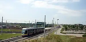 Luas Red Line tram passes Red Cow depot | |
| Overview | |
| Status | Operational |
| Owner | Transport Infrastructure Ireland |
| Locale | Ireland |
| Termini | |
| Stations | 32 |
| Service | |
| Type | Light rail |
| Operator(s) | Transdev |
| Depot(s) | Red Cow |
| History | |
| Opened | 26 September 2004 |
| Technical | |
| Line length | 13 miles (21 km) |
| Number of tracks | Double track |
| Character | Primary |
| Track gauge | 1,435 mm (4 ft 8+1⁄2 in) standard gauge |
| Electrification | 750 V DC Overhead catenary |
The Red Line (Irish: Líne Dhearg[1]) is one of the two lines of Dublin's Luas light rail system. The Red Line runs in an east–west direction through the city centre, north of the River Liffey, before travelling southwest to Tallaght, with a fork to Citywest and Saggart. The Red Line opened on 26 September 2004.
History
Construction work began in March 2001 on the Tallaght to Connolly line, as well as the Sandyford to St. Stephen's Green section of the second line, with Ansaldo of Italy and MVM of Australia getting the contract to build the system.[2] The St. Stephen's Green to Dublin Airport section was dropped before construction began, as it was decided to serve the area by a metro instead. The contract to maintain operate the system was awarded to Transdev Ireland (formerly known as Connex).[3]
The extension from Connolly to The Point opened in 2009,[4] with the extension from Belgard to Saggart opening in 2011.[5]
Interchange with the Green Line began in December 2017 with its extension crossing the Red Line either side of the Abbey Street stop.[6]
Rolling stock
The Luas Red Line is operated using Citadis trams.
Depot
The tram depot for the Red Line is located at Red Cow where the main control room for the entire Luas system is also located.[7]
Route
| Image | Name Name in Irish |
Branch | Zone | Location | Transport interchange | Serves |
|---|---|---|---|---|---|---|
 |
The Point Iosta na Rinne |
Docklands (Terminus) | Red 1 | Mayor Street Upper 53°20′54″N 6°13′45″W / 53.348338°N 6.229195°W |
|
3Arena |
 |
Spencer Dock Duga Spencer |
Docklands | Red 1 | Mayor Street Upper 53°20′56″N 6°14′14″W / 53.348806°N 6.237134°W |
Convention Centre Dublin | |
 |
Mayor Square — NCI Cearnóg an Mhéara — CNÉ |
Docklands | Red 1 | Mayor Street Lower 53°20′57″N 6°14′36″W / 53.349203°N 6.243276°W |
National College of Ireland | |
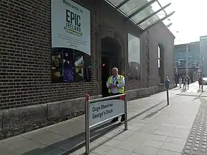 |
George's Dock Duga Sheoirse |
Docklands | Red 1 / Central | George's Dock 53°20′58″N 6°14′51″W / 53.349440°N 6.247562°W |
Jeanie Johnston | |
 |
Connolly Conghaile |
Connolly (Terminus) | Red 1 / Central | Amiens Street 53°21′04″N 6°15′00″W / 53.351025°N 6.250121°W |
|
National College of Ireland |
.jpg.webp) |
Busáras | Main line | Red 1 / Central | Store Street 53°21′00″N 6°15′06″W / 53.350100°N 6.251607°W |
|
Busáras The Custom House International Financial Services Centre |
 |
Abbey Street Sráid na Mainistreach |
Main line | Central | Lower Abbey Street 53°20′55″N 6°15′31″W / 53.348556°N 6.258490°W |
O'Connell Street, O'Connell Bridge, Abbey Street Abbey Theatre Trinity College Dublin | |
 |
Jervis | Main line | Central | Upper Abbey Street 53°20′52″N 6°15′55″W / 53.347711°N 6.265265°W |
Henry Street, Parnell Street, Temple Bar Jervis Shopping Centre St. Mary's Abbey | |
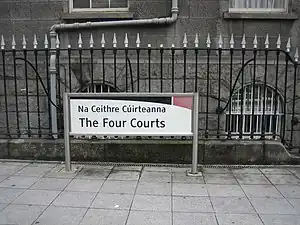 |
The Four Courts Na Ceithre Cúirteanna |
Main line | Central | between Greek Street and Church Street 53°20′49″N 6°16′25″W / 53.346846°N 6.273676°W |
Four Courts Wood Quay DCC Civic Offices St. Audoen's Church St. Michan's Church | |
.jpg.webp) |
Smithfield Margadh na Feirme |
Main line | Central | Phoenix Street North 53°20′50″N 6°16′41″W / 53.347114°N 6.278054°W |
Old Jameson Distillery Smithfield Light House Cinema Brown Bag Films | |
.jpg.webp) |
Museum Músaem |
Main line | Central | Croppies' Acre 53°20′52″N 6°17′13″W / 53.347880°N 6.286927°W |
National Museum of Ireland – Decorative Arts and History Arbour Hill Prison | |
_at_Heuston_station%252C_June_2005.jpg.webp) |
Heuston | Main line | Central / Red 2 | Dublin Heuston railway station 53°20′48″N 6°17′31″W / 53.346666°N 6.291811°W |
St. Patrick's Hospital Phoenix Park | |
 |
James's Ospidéal San Séamas |
Main line | Red 2 | James's Street 53°20′30″N 6°17′36″W / 53.341763°N 6.293361°W |
National College of Art and Design St. James's Hospital Guinness Storehouse | |
 |
Fatima | Main line | Red 2 | James's Walk 53°20′18″N 6°17′34″W / 53.338450°N 6.292809°W |
Dolphin's Barn, The Coombe The Liberties Coombe Women & Infants University Hospital | |
 |
Rialto | Main line | Red 2 | James's Walk 53°20′16″N 6°17′51″W / 53.337909°N 6.297401°W |
|
Rialto, New National Children's Hospital, Kilmainham |
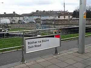 |
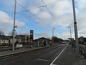
Suir Road Bóthar na Siúire |
Main line | Red 2/3 | Davitt Road 53°20′12″N 6°18′26″W / 53.336643°N 6.307255°W |
Inchicore, Kilmainham Richmond Park Good Counsel GAA Inchicore College of Further Education Irish Museum of Modern Art Royal Hospital Kilmainham Kilmainham Gaol | |
 |
Goldenbridge An Droichead Órga |
Main line | Red 3 | Davitt Road 53°20′09″N 6°18′48″W / 53.335916°N 6.313301°W |
Goldenbridge Cemetery | |
 |
Drimnagh Droimeanach |
Main line | Red 3 | Davitt Road 53°20′07″N 6°19′06″W / 53.335349°N 6.318290°W |
Our Lady's Children's Hospital, Crumlin Richmond Barracks Goldenbridge Cemetery | |
 |
Blackhorse An Capall Dubh |
Main line | Red 3 | Mayor Street Upper 53°20′03″N 6°19′39″W / 53.334273°N 6.327543°W |
Goldenbridge Industrial Estate Lansdowne Valley Park Westlink Industrial Estate | |
| Bluebell An Cloigín Gorm |
Main line | Red 3 | Naas Road 53°19′46″N 6°20′02″W / 53.329327°N 6.333895°W |
Drimnagh Drimnagh Castle Lansdowne Valley Park | ||
 |
Kylemore An Chill Mhór |
Main line | Red 3 | Naas Road 53°19′36″N 6°20′38″W / 53.326639°N 6.343814°W |
Walkinstown St James Gaels GAA Kylemore College | |
|
Red Cow An Bhó Dhearg |
Main line | Red 3 | Red Cow interchange 53°18′59″N 6°22′13″W / 53.316307°N 6.370167°W |
Ballymount Park | |
 |
Kingswood Coill an Rí |
Main line | Red 3 | R838 53°18′13″N 6°21′56″W / 53.303638°N 6.365452°W |
Tallaght Medical Centre | |
.jpg.webp) |
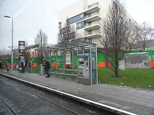
Belgard | Main line | Red 3/4 | Old Belgard Road 53°17′57″N 6°22′30″W / 53.299256°N 6.375135°W |
Belgard, Kilnamanagh Kilnamanagh Shopping Centre | |
.jpg.webp) |
Fettercairn Fothair Chardain |
Saggart line | Red 4 | Katherine Tynan Road 53°17′36″N 6°23′45″W / 53.293325°N 6.395937°W |
Fettercairn St Marks GAA Saint Anne's School | |
%252C_Citywest_Avenue%252C_Cheeverstown%252C_Dublin_(geograph_5467443).jpg.webp) |
Cheeverstown Baile an tSíbhrigh |
Saggart line | Red 4 | Cheeverstown 53°17′28″N 6°24′23″W / 53.291045°N 6.406500°W |
Luas Park + Ride |
Cheeverstown |
| Citywest Campus Campas Gnó Iarthar na Cathrach |
Saggart line | Red 4 | Citywest Avenue 53°17′18″N 6°25′04″W / 53.288460°N 6.417647°W |
|
Citywest Citywest Village | |
| Fortunestown - Citywest Shopping Centre Baile Uí Fhoirtcheirn |
Saggart line | Red 4 | Citywest Drive 53°17′03″N 6°25′29″W / 53.284253°N 6.424782°W |
|
Fortunestown Citywest Citywest Shopping Centre | |
.jpg.webp) |
Saggart Teach Sagard |
Saggart line (Terminus) | Red 4 | Saggart 53°17′05″N 6°26′16″W / 53.284785°N 6.437801°W |
Saggart, Whitechurch, Baldonnel, Rathcoole Citywest Educate Together N.S. Citywest Hotel Casement Aerodrome | |
 |
Cookstown Baile an Chócaigh |
Tallaght line | Red 4 | Cookstown Way 53°17′36″N 6°23′03″W / 53.293305°N 6.384044°W |
Cookstown St. Mark's Community School | |
 |
Hospital Ospidéal Tamhlachta |
Tallaght line | Red 4 | Cookstown Way 53°17′21″N 6°22′44″W / 53.289277°N 6.379002°W |
Tallaght University Hospital | |
 |
Tallaght Tamhlacht |
Tallaght line (Terminus) | Red 4 | Hibernian Industrial Estate 53°17′15″N 6°22′28″W / 53.287424°N 6.374581°W |
|
Tallaght Institute of Technology, Tallaght Tallaght Stadium Civic Theatre The Square Shopping Centre |
See also
References
- ↑ "Luas - Welcome to Luas, Dublin's Light Rail Tram System". Archived from the original on 24 March 2017. Retrieved 22 February 2015.
- ↑ "O'Rourke awards £196m LUAS contract". RTÉ News. 8 March 2001. Archived from the original on 26 October 2012. Retrieved 16 October 2013.
- ↑ "Luas home page". Railway Procurement Agency. Archived from the original on 12 March 2008. Retrieved 4 April 2008.
- ↑ O'Brien, Tim (9 December 2009). "New Luas extension through Docklands opens". The Irish Times. Archived from the original on 28 June 2021. Retrieved 5 September 2020.
- ↑ Kelly, Olivia (2 July 2011). "Minister opens Luas Red Line branch to Citywest and Saggart". The Irish Times. Archived from the original on 18 December 2019. Retrieved 5 September 2020.
- ↑ "Luas Green Line extension a major boost for Dublin". Transport Infrastructure Ireland. 9 December 2017. Archived from the original on 24 June 2021. Retrieved 2 September 2019.
- ↑ "Luas to improve backup plans following storm-related service disruptions". The Irish Times. 20 October 2017. Archived from the original on 3 November 2017. Retrieved 28 February 2019.
- ↑ https://www.dublinbus.ie/Global/N4-timetable%20June%202022.pdf