| Mūša, Mūsa | |
|---|---|
.png.webp) Map highlighting Mūša | |
| Location | |
| Country | Lithuania and Latvia |
| Physical characteristics | |
| Source | |
| • location | Joniškis district |
| Mouth | Lielupe |
• location | Bauska |
• coordinates | 56°24′10″N 24°9′34″E / 56.40278°N 24.15944°E |
| Length | 164 km (102 mi) |
| Basin size | 5,318 km2 (2,053 sq mi) |
| Basin features | |
| Progression | Lielupe→ Baltic Sea |
| Tributaries | |
| • right | Kruoja, Lėvuo, Pyvesa, Tatula |
Mūša (Latvian: Mūsa; German: Muhsse) is a river in Northern Lithuania and Southern Latvia (Zemgale region). At its confluence with the river Nemunėlis (Latvian: Mēmele) in Latvia, near the city of Bauska, the river Lielupė is formed. The river is 164 kilometers (146 km in Lithuania, 18 km in Latvia) long.
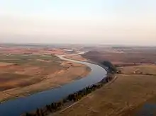
Mūša in Pasvalys district, Lithuania
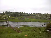
Pedestrian bridge over Mūsa in Bauska
References
- LIETUVOS RESPUBLIKOS UPIŲ IR TVENKINIŲ KLASIFIKATORIUS (Republic of Lithuania- River and Pond Classifications). Ministry of Environment (Lithuania). Accessed 2011-11-17.
This article is issued from Wikipedia. The text is licensed under Creative Commons - Attribution - Sharealike. Additional terms may apply for the media files.