| Ma'an Dam 馬鞍壩 | |
|---|---|
 | |
_location_map.svg.png.webp) Location of Ma'an Dam 馬鞍壩 in Taichung | |
| Location | Heping, Taichung, Taiwan |
| Coordinates | 24°11′03″N 120°54′50″E / 24.18417°N 120.91389°E |
| Purpose | hydroelectricity |
| Status | Operational |
| Construction began | 1992 |
| Opening date | 1998 |
| Dam and spillways | |
| Type of dam | concrete gravity barrage dam |
| Impounds | Dajia River |
| Height | 16.3 m (53 ft) |
| Length | 229.5 m (753 ft) |
| Spillways | 9 |
| Spillway capacity | 6,380 m3/s (225,000 cu ft/s) |
| Reservoir | |
| Total capacity | 965,000 m3 (782 acre⋅ft) |
| Power Station | |
| Turbines | 2 X 66.735 MW |
| Installed capacity | 133.47 MW |
| Annual generation | 410.2 GWh |
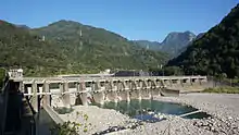
The Ma'an Dam (traditional Chinese: 馬鞍壩; simplified Chinese: 马鞍坝; pinyin: Mǎ'ān Bà, 'Saddle Dam') is a concrete gravity barrage dam on the Dajia River in Heping District, Taichung, Taiwan. The dam is the final stage of a cascade of hydroelectric power plants along the Dajia River and is located below the Tienlun Dam.
Built from 1992 to 1998, the dam is 16.3 m (53 ft) high and 229.5 m (753 ft) long, storing up to 965,000 m3 (782 acre⋅ft) in its reservoir. The service spillway of the dam consists of nine gates with a combined capacity of 6,380 m3/s (225,000 cu ft/s).[1]
The dam supplies water through a tunnel to a 133.47 MW power station near Xinshe with two 66.735 MW turbines, generating 410.2 million kilowatt hours per year.[2]
See also
References
- ↑ Reservoirs and Weirs in Taiwan (in Chinese). Taiwan Water Resources Agency, Ministry of Public Affairs. p. 328.
- ↑ 大甲溪 (PDF) (in Chinese). Taiwan Water Resources Agency. 2009-01-22. Archived from the original (PDF) on 2011-08-15. Retrieved 2013-06-25.
Wikimedia Commons has media related to Ma'an Dam.
This article is issued from Wikipedia. The text is licensed under Creative Commons - Attribution - Sharealike. Additional terms may apply for the media files.