Maloja District
Bezirk Maloja Distretto di Maloggia District da Malögia | |
|---|---|
District | |
 | |
| Country | |
| Canton | |
| Capital | Samedan |
| Area | |
| • Total | 973.61 km2 (375.91 sq mi) |
| Population (2020) | |
| • Total | 18,698 |
| • Density | 19/km2 (50/sq mi) |
| Time zone | UTC+1 (CET) |
| • Summer (DST) | UTC+2 (CEST) |
| Municipalities | 16 |
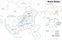
Maloja District (Romansh: ⓘ, Italian: Distretto di Maloja) is a former administrative district in the canton of Graubünden (or Grigioni), Switzerland. It had an area of 973.28 km2 (375.79 sq mi) and had a population of 18,698 in 2015. It was replaced with the Maloja Region on 1 January 2017 as part of a reorganization of the Canton.[1]
It was trilingual, with official languages used by municipalities inside the district being, in order of dominance, German, Italian, and Romansh.
It consisted of two Kreis or circoli in Italian (sub-districts) and sixteen municipalities:
| Bregaglia sub-district | ||||
|---|---|---|---|---|
| Municipality | Population (31 December 2020)[2] |
Area (km2) | ||
| Bregaglia | 1,556 | 251.45 | ||
| Oberengadin sub-district | ||||
|---|---|---|---|---|
| Municipality | Population (31 December 2020)[2] |
Area (km2) | ||
| Bever | 584 | 45.65 | ||
| Celerina/Schlarigna | 1,484 | 24.03 | ||
| La Punt Chamues-ch | 686 | 63.22 | ||
| Madulain | 206 | 16.35 | ||
| Pontresina | 2,178 | 118.24 | ||
| St. Moritz | 4,945 | 28.69 | ||
| Samedan | 2,923 | 113.97 | ||
| S-chanf | 697 | 137.90 | ||
| Sils im Engadin/Segl | 715 | 63.54 | ||
| Silvaplana | 1,121 | 44.71 | ||
| Zuoz | 1,199 | 65.62 | ||
Languages
All three of Graubünden's official languages: German, Romansh, and Italian, can be heard in the district. Except for the municipality of Bregaglia, the area was predominantly Romansh-speaking. Today, Romansh is spoken the least out of the three official languages of Maloja.
| Languages of Maloja District, GR[3] | ||||||||
| Languages | Census 1970 | Census 1980 | Census 1990 | Census 2000 | ||||
| Number | Percent | Number | Percent | Number | Percent | Number | Percent | |
| German | 6,567 | 41.3% | 7,269 | 44.7% | 8,643 | 52.6% | 10,474 | 55.7% |
| Romansh | 3,340 | 21.0% | 3,489 | 21.5% | 2,722 | 16.6% | 2,312 | 12.3% |
| Italian | 4,950 | 31.1% | 4,271 | 26.3% | 3,705 | 22.6% | 4,004 | 21.3% |
| TOTAL | 15,910 | 100% | 16,252 | 100% | 16,420 | 100% | 18,813 | 100% |
References
- ↑ Swiss Federal Statistical Office - Amtliches Gemeindeverzeichnis der Schweiz - Mutationsmeldungen 2016 accessed 16 February 2017
- 1 2 "Ständige und nichtständige Wohnbevölkerung nach institutionellen Gliederungen, Geburtsort und Staatsangehörigkeit". bfs.admin.ch (in German). Swiss Federal Statistical Office - STAT-TAB. 31 December 2020. Retrieved 21 September 2021.
- ↑ Swiss Federal Statistical Office, Wohnbevölkerung am wirtschaftlichen Wohnsitz nach institutionellen Gliederungen, Hauptsprache und Nationalität, 1970-2000 (in German) accessed 6 September 2016
46°24′9″N 9°41′42″E / 46.40250°N 9.69500°E