Manorom
มโนรมย์ | |
|---|---|
 Chao Phraya River flows through Manorom community | |
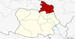 District location in Chai Nat province | |
| Coordinates: 15°18′34″N 100°5′2″E / 15.30944°N 100.08389°E | |
| Country | Thailand |
| Province | Chai Nat |
| Seat | Khung Samphao |
| Area | |
| • Total | 225.644 km2 (87.122 sq mi) |
| Population (2014) | |
| • Total | 32,847 |
| • Density | 147.9/km2 (383/sq mi) |
| Time zone | UTC+7 (ICT) |
| Postal code | 17110 |
| Geocode | 1802 |
Manorom (Thai: มโนรมย์, pronounced [mā.nōː.rōm]) is a district (amphoe) in the northeastern part of Chai Nat province, central Thailand.
Geography
Neighboring districts are (from the south clockwise) Mueang Chainat and Wat Sing of Chainat Province; Mueang Uthai Thani of Uthai Thani province; Phayuha Khiri and Takhli of Nakhon Sawan province.
Administration
Central administration
Manorom is divided into seven sub-districts (tambons), which are further subdivided into 40 administrative villages (mubans).
| No. | Name | Thai | Villages | Pop.[1] |
|---|---|---|---|---|
| 1. | Khung Samphao | คุ้งสำเภา | 4 | 5,719 |
| 2. | Wat Khok | วัดโคก | 5 | 3,817 |
| 3. | Sila Dan | ศิลาดาน | 6 | 3,509 |
| 4. | Tha Chanuan | ท่าฉนวน | 10 | 6,796 |
| 5. | Hang Nam Sakhon | หางน้ำสาคร | 5 | 5,743 |
| 6. | Rai Phatthana | ไร่พัฒนา | 5 | 3,830 |
| 7. | U Taphao | อู่ตะเภา | 5 | 3,433 |
Local administration
There are four sub-district municipalities (thesaban tambon) in the district:
- Khung Samphao (Thai: เทศบาลตำบลคุ้งสำเภา) consisting of parts of sub-district Khung Samphao.
- Hang Nam Sakhon (Thai: เทศบาลตำบลหางน้ำสาคร) consisting of sub-district Hang Nam Sakhon and parts of sub-district U Taphao.
- Manorom (Thai: เทศบาลตำบลมโนรมย์) consisting of parts of sub-district Khung Samphao.
- Sila Dan (Thai: เทศบาลตำบลศิลาดาน) consisting of sub-district Sila Dan.
There are four sub-district administrative organizations (SAO) in the district:
- Wat Khok (Thai: องค์การบริหารส่วนตำบลวัดโคก) consisting of sub-district Wat Khok.
- Tha Chanuan (Thai: องค์การบริหารส่วนตำบลท่าฉนวน) consisting of sub-district Tha Chanuan.
- Rai Phatthana (Thai: องค์การบริหารส่วนตำบลไร่พัฒนา) consisting of sub-district Rai Phatthana.
- U Taphao (Thai: องค์การบริหารส่วนตำบลอู่ตะเภา) consisting of parts of sub-district U Taphao.
References
- ↑ "Population statistics 2014" (in Thai). Department of Provincial Administration. Retrieved 2015-12-12.
External links
- amphoe.com (Thai)
This article is issued from Wikipedia. The text is licensed under Creative Commons - Attribution - Sharealike. Additional terms may apply for the media files.