Huron East | |
|---|---|
| Municipality of Huron East | |
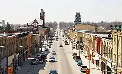 Seaforth | |
 Huron East | |
| Coordinates: 43°38′N 81°17′W / 43.63°N 81.28°W | |
| Country | |
| Province | |
| County | Huron |
| Settled | 1830s |
| Formed | 2001 |
| Government | |
| • Mayor | Bernie MacLellan |
| • Deputy Mayor | Alvin McLellan |
| • Federal riding | Huron—Bruce |
| • Prov. riding | Huron—Bruce |
| Area | |
| • Land | 669.26 km2 (258.40 sq mi) |
| Population (2021)[2] | |
| • Total | 9,512 |
| • Density | 13.8/km2 (36/sq mi) |
| Time zone | UTC-5 (EST) |
| • Summer (DST) | UTC-4 (EDT) |
| Postal Code | N0K, N0G |
| Area code(s) | 519 and 226 |
| Website | www |
The Municipality of Huron East is a Canadian municipality located in Huron County, Ontario. It was formed in 2001 as an amalgamation of the former Grey, McKillop and Tuckersmith townships with the town of Seaforth and village of Brussels, due to an Ontario-wide local government restructuring imposed by the government of that time. The municipality is structured as five wards based on the former townships, town and village.
Geography
Communities
Besides the town of Seaforth and the village of Brussels, the municipality of Huron East comprises a number of villages and hamlets, including:
- Former Grey Township: - Brussels,[lower-alpha 1] Cranbrook, Ethel, Molesworth[lower-alpha 2] Walton;[lower-alpha 1] Henfryn,[lower-alpha 2] Ethel Siding, Jamestown,[lower-alpha 1] McNaught, Moncrieff, Silver Corners[lower-alpha 2]
- Former McKillop Township: - St. Columban,[lower-alpha 3] Seaforth, Winthrop; Leadbury, Dublin,[lower-alpha 3] Beachwood, Manley, Roxboro, Slabtown[lower-alpha 3]
- Former Tuckersmith Township: - Brucefield,[lower-alpha 4] Egmondville, Harpurhey, Hensall,[lower-alpha 5] Kippen,[lower-alpha 4] Vanastra;[lower-alpha 6] Clinton,[lower-alpha 6] Chiselhurst[lower-alpha 3]
- Notes
- 1 2 3 Shared with the Municipality of Morris-Turnberry.
- 1 2 3 Shared with the Municipality of North Perth, within Perth County.
- 1 2 3 4 Shared with the Municipality of West Perth, within Perth County.
- 1 2 Shared with the Municipality of Bluewater.
- ↑ Partially shared with the Municipality of Bluewater; former village.
- 1 2 Shared with the Municipality of Central Huron.
Demographics
| Year | Pop. | ±% |
|---|---|---|
| 1996 | 9,937 | — |
| 2001 | 9,680 | −2.6% |
| 2006 | 9,310 | −3.8% |
| 2011 | 9,264 | −0.5% |
| 2016 | 9,138 | −1.4% |
| 2021 | 9,512 | +4.1% |
| [3][1][4][2] | ||
In the 2021 Census of Population conducted by Statistics Canada, Huron East had a population of 9,512 living in 3,707 of its 3,912 total private dwellings, a change of 4.1% from its 2016 population of 9,138. With a land area of 669.15 km2 (258.36 sq mi), it had a population density of 14.2/km2 (36.8/sq mi) in 2021.[5]
See also
References
- 1 2 "Huron East, Ontario (Code 3540040) census profile". 2011 Census of Population. Statistics Canada. Archived from the original on 2016-03-04. Retrieved 2012-08-10.
- 1 2 "Census Profile, 2021 Census Huron East, Ontario". Statistics Canada. Retrieved February 27, 2022.
- ↑ Statistics Canada: 1996, 2001, 2006
- ↑ "Census Profile, 2016 Census Huron East, Ontario". Statistics Canada. Retrieved April 27, 2019.
- ↑ "Population and dwelling counts: Canada, provinces and territories, census divisions and census subdivisions (municipalities), Ontario". Statistics Canada. February 9, 2022. Retrieved March 31, 2022.
External links
Places adjacent to Huron East, Ontario | |
|---|---|