Mogalhat | |
|---|---|
| Bangladesh Railway Station | |
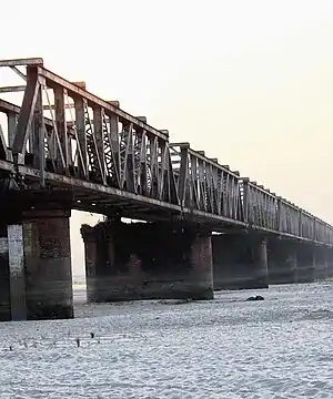
 Remains of Old Railway Bridge | |
| General information | |
| Location | Lalmonirhat, Rangpur Bangladesh |
| Coordinates | 25°59′32″N 89°27′07″E / 25.99224°N 89.45184°E |
| Other information | |
| Status | Line out of service |
| History | |
| Opened | 1896 |
| Closed | 1965 |
| Previous names | Northern Bengal State Railway |
Mogalhat (Bengali: মোগলহাট) is a border railway station in Bangladesh, situated in Lalmonirhat District, in Rangpur Division. It is a defunct railway transit point on the Bangladesh-India border.
History
By the turn of the nineteenth century Lalmonirhat railway station had emerged as an important railway centre. Bengal Dooars Railway constructed a line to Malbazar. Cooch Behar State Railway constructed the Geetaldaha-Jayanti narrow gauge line. Links were established with Assam, with the Golokganj-Amingaon line coming up. In pre-independence days, a metre gauge line running via Radhikapur, Biral, Parbatipur, Tista, Gitaldaha and Golokganj connected Fakiragram in Assam with Katihar in Bihar.[1][2][3][4]
Defunct Lalmonirhat–Geetaldaha line | |||||||||||||||||||||||||||||||||||||||||||||||||||||||||||||||||
|---|---|---|---|---|---|---|---|---|---|---|---|---|---|---|---|---|---|---|---|---|---|---|---|---|---|---|---|---|---|---|---|---|---|---|---|---|---|---|---|---|---|---|---|---|---|---|---|---|---|---|---|---|---|---|---|---|---|---|---|---|---|---|---|---|---|
| |||||||||||||||||||||||||||||||||||||||||||||||||||||||||||||||||
| |||||||||||||||||||||||||||||||||||||||||||||||||||||||||||||||||
The Mogalhat-Geetaldaha link was there in 1955, when Pakistan and India signed an agreement regarding resumption of rail traffic.[5] Subsequently, a part of the bridge across the Dharla River at 26°00′11″N 89°28′10″E / 26.00304°N 89.46934°E was washed away transforming Mogalhat-Geetaldaha, a defunct railway transit point.
Note: The map below presents the position as it stands today (2020). The international border was not there when the railways were first laid in the area in the 19th-20th century. It came up in 1947. Since then, it has been an effort to live up to the new realities. The map is 'Interactive' (the larger version) - it means that all the places shown in the map are linked in the full screen map.
CT: census town, R: rural/ urban centre, RS: railway station
Owing to space constraints in the small map, the actual locations in a larger map may vary slightly
References
- ↑ R.P. Saxena. "Indian Railway History timeline". Archived from the original on 2012-07-14. Retrieved 2012-02-01.
- ↑ "Bengal Dooars Railway". Fibis. Retrieved 2011-11-20.
- ↑ "Geography - International". IRFCA. Retrieved 2011-12-10.
- ↑ "Prospect to establish Quadrilateral business link". Bangla 2000, 10 October 2000. Retrieved 2012-02-01.
- ↑ "No. 3458, Pakistan and india, Agreement regarding resumption of rail traffic. Signed at Karachi on 15 April 1955" (PDF). Retrieved 2012-01-28.