Schönbrunn | |
|---|---|
 | |
_COA.svg.png.webp) Coat of arms | |
Location of Schönbrunn within Rhein-Neckar-Kreis district 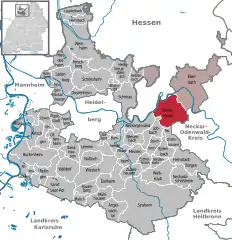 | |
 Schönbrunn  Schönbrunn | |
| Coordinates: 49°24′42″N 08°55′39″E / 49.41167°N 8.92750°E | |
| Country | Germany |
| State | Baden-Württemberg |
| Admin. region | Karlsruhe |
| District | Rhein-Neckar-Kreis |
| Government | |
| • Mayor (2016–24) | Jan Frey[1] (CDU) |
| Area | |
| • Total | 34.48 km2 (13.31 sq mi) |
| Elevation | 398 m (1,306 ft) |
| Population (2021-12-31)[2] | |
| • Total | 2,894 |
| • Density | 84/km2 (220/sq mi) |
| Time zone | UTC+01:00 (CET) |
| • Summer (DST) | UTC+02:00 (CEST) |
| Postal codes | 69436 |
| Dialling codes | 06272, 06262, 06271 |
| Vehicle registration | HD |
| Website | www.gemeinde-schoenbrunn.de |
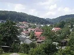
Schönbrunn (German pronunciation: [ˈʃøːnˌbʁʊn] ⓘ) is a municipality in the Rhein-Neckar district, Baden-Württemberg, Germany. It consists of the villages Allemühl, Haag, Moosbrunn, Schönbrunn and Schwanheim. It is situated in the southern part of the Odenwald hills, south of the river Neckar. Schönbrunn lies about 7 km southwest of Eberbach and 18 km east of Heidelberg.
Transport
The nearest train stations are in Hirschhorn and Eberbach, on the Neckar Valley Railway. Buses of the Verkehrsverbund Rhein-Neckar connect Schönbrunn with Eberbach, Mosbach and Heidelberg.
References
- ↑ Aktuelle Wahlergebnisse, Staatsanzeiger, accessed 14 September 2021.
- ↑ "Bevölkerung nach Nationalität und Geschlecht am 31. Dezember 2021" [Population by nationality and sex as of December 31, 2021] (CSV) (in German). Statistisches Landesamt Baden-Württemberg. June 2022.
External links
 Media related to Schönbrunn (Baden) at Wikimedia Commons
This article is issued from Wikipedia. The text is licensed under Creative Commons - Attribution - Sharealike. Additional terms may apply for the media files.