| Mount Kamui | |
|---|---|
| 神威岳 | |
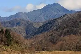 A view from Motourakawa River | |
| Highest point | |
| Elevation | 1,600.5 m (5,251 ft) |
| Listing | List of mountains and hills of Japan by height |
| Coordinates | 42°25′42″N 142°54′24″E / 42.42833°N 142.90667°E |
| Naming | |
| English translation | Mountain of the Gods |
| Language of name | Ainu |
| Geography | |
| Location | Hokkaidō, Japan |
| Parent range | Hidaka Mountains |
| Topo map | Geographical Survey Institute (国土地理院, Kokudochiriin) 25000:1 神威岳, 50000:1 神威岳 |
| Geology | |
| Mountain type | Fold |
Mount Kamui (神威岳, kamuidake) is located in the Hidaka Mountains, Hokkaidō, Japan.
References
- Shyun Umezawa, Yasuhiko Sugawara, and Jun Nakagawa, Hokkaidō Natsuyama Gaido 4: Hidaka Sanmyaku no Yamayama (北海道夏山ガイド4日高山脈の山やま), Sapporo, Hokkaidō Shimbunshya, 1991. ISBN 4-89363-605-7
- Google maps
- Geographical Survey Institute
This article is issued from Wikipedia. The text is licensed under Creative Commons - Attribution - Sharealike. Additional terms may apply for the media files.