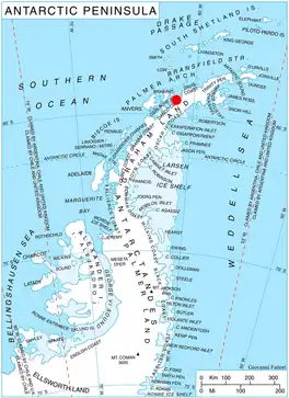
Location of Pefaur (Ventimiglia) Peninsula on Danco Coast, Antarctic Peninsula.
Mount Zeppelin (64°27′S 61°31′W / 64.450°S 61.517°W) is an Antarctic mountain, 1,265 m, standing 3 miles (4.8 km) southeast of Eckener Point on Pefaur (Ventimiglia) Peninsula, Danco Coast on the west coast of Graham Land. It surmounts Poduene Glacier to the north. Mount Zeppelin was charted by the Belgian Antarctic Expedition under Gerlache, 1897–99. Named by the United Kingdom Antarctic Place-Names Committee (UK-APC) in 1960 for Count Ferdinand von Zeppelin (1838-1917), German aeronautical engineer who perfected the large-scale rigid airship, 1894–1917.
Map
- British Antarctic Territory. Scale 1:200000 topographic map. DOS 610 Series, Sheet W 64 60. Directorate of Overseas Surveys, Tolworth, UK, 1978.
References
![]() This article incorporates public domain material from "Mount Zeppelin". Geographic Names Information System. United States Geological Survey.
This article incorporates public domain material from "Mount Zeppelin". Geographic Names Information System. United States Geological Survey.
This article is issued from Wikipedia. The text is licensed under Creative Commons - Attribution - Sharealike. Additional terms may apply for the media files.