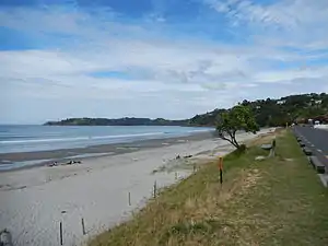
Onetangi | |
|---|---|
 Onetangi Beach | |
| Coordinates: 36°47′17″S 175°04′52″E / 36.788°S 175.081°E | |
| Country | New Zealand |
| City | Auckland |
| Local authority | Auckland Council |
| Electoral ward | Waitematā and Gulf ward |
| Local board | Waiheke Local Board |
| Area | |
| • Land | 596 ha (1,473 acres) |
| Population (June 2022)[2] | |
| • Total | 1,360 |
| (Onetangi Bay) | ||
| Palm Beach |
|
Rural Waiheke |
| Ostend | Rural Waiheke |
Onetangi is a settlement on the north coast of Waiheke Island in New Zealand. It has a long white-sand beach fronting onto Onetangi Bay.[3]
The name means "Weeping Sands" in the Māori language, and comes from a battle in 1821 during the Musket Wars.[4][5] The area was subdivided for settlement in 1921.[6]
The Museum of Waiheke opened in Onetangi in 1990.[7][8] The beachfront is a popular area for holiday-makers and locals whom enjoy the temperate climate and fishing in the area. The bay also contains two restaurants; Charlie Farley’s and Three Seven Two.
Demographics
Onetangi covers 5.96 km2 (2.30 sq mi)[1] and had an estimated population of 1,360 as of June 2022,[2] with a population density of 228 people per km2.
| Year | Pop. | ±% p.a. |
|---|---|---|
| 2006 | 1,155 | — |
| 2013 | 1,134 | −0.26% |
| 2018 | 1,302 | +2.80% |
| Source: [9] | ||
Onetangi had a population of 1,302 at the 2018 New Zealand census, an increase of 168 people (14.8%) since the 2013 census, and an increase of 147 people (12.7%) since the 2006 census. There were 513 households, comprising 657 males and 645 females, giving a sex ratio of 1.02 males per female. The median age was 46.7 years (compared with 37.4 years nationally), with 222 people (17.1%) aged under 15 years, 156 (12.0%) aged 15 to 29, 663 (50.9%) aged 30 to 64, and 261 (20.0%) aged 65 or older.
Ethnicities were 89.6% European/Pākehā, 12.2% Māori, 3.9% Pacific peoples, 3.5% Asian, and 4.1% other ethnicities. People may identify with more than one ethnicity.
The percentage of people born overseas was 30.6, compared with 27.1% nationally.
Although some people chose not to answer the census's question about religious affiliation, 62.7% had no religion, 24.0% were Christian, 1.4% had Māori religious beliefs, 0.7% were Buddhist and 2.3% had other religions.
Of those at least 15 years old, 303 (28.1%) people had a bachelor's or higher degree, and 123 (11.4%) people had no formal qualifications. The median income was $34,000, compared with $31,800 nationally. 222 people (20.6%) earned over $70,000 compared to 17.2% nationally. The employment status of those at least 15 was that 540 (50.0%) people were employed full-time, 186 (17.2%) were part-time, and 18 (1.7%) were unemployed.[9]
References
- 1 2 "ArcGIS Web Application". statsnz.maps.arcgis.com. Retrieved 29 July 2022.
- 1 2 "Population estimate tables - NZ.Stat". Statistics New Zealand. Retrieved 25 October 2022.
- ↑ "Discover - Onetangi Beach". Waiheke Local. Retrieved 25 August 2020.
- ↑ Easther, Elizabeth (14 February 2014). "Kia ora: Onetangi". New Zealand Herald.
- ↑ Caldwell, Andrew (May–June 2010). "The Island of the Day Before…". New Zealand Geographic. No. 103. Sidebar: Weeping Sands.
- ↑ "The history of human settlement of the islands" (PDF). Auckland Council. 2013. p. 6.
- ↑ "Museum of Waiheke". Museum of Waiheke.
- ↑ "Waiheke Island Historic Museum on NZ Museums". nzmuseums.co.nz. Te Papa.
- 1 2 "Statistical area 1 dataset for 2018 Census". Statistics New Zealand. March 2020. Onetangi (151100). 2018 Census place summary: Onetangi