Northern Borders Province
الحدود الشمالية Al-Ḥudūd Al-Shamāliyyah | |
|---|---|
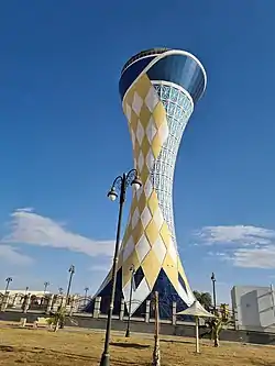 Arar Water Tower in Arar, the capital of the Northern Borders Region | |
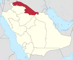 Map of Saudi Arabia with Northern Borders Province highlighted | |
| Coordinates: 30°0′N 42°30′E / 30.000°N 42.500°E | |
| Country | |
| Capital | 'Ar'ar |
| Boroughs | 3 |
| Government | |
| • Governor | Faisal bin Khalid bin Sultan bin Abdulaziz Al Saud |
| Area | |
| • Total | 111,797 km2 (43,165 sq mi) |
| Population (2010) | |
| • Total | 375,310 |
| • Density | 3.4/km2 (8.7/sq mi) |
| ISO 3166-2 | 08 |
The Northern Borders Province (Arabic: منطقة الحدود الشمالية Al-Ḥudūd Aš-Šamāliyya) is the least populated province of Saudi Arabia. It is located in the north of the country, bordering Iraq and Jordan. It has an area of 111,797 km2 and a population of 320,524 at the 2010 census.[1] The region is sub-divided into three governorates: Arar, Rafha and Turayf. Its capital is Arar.
Population
| Year | Pop. | ±% p.a. |
|---|---|---|
| 1992 | 229,060 | — |
| 2004 | 279,971 | +1.69% |
| 2010 | 321,880 | +2.35% |
| 2018 | 375,310 | +1.94% |
| source:[2] | ||
Administrative divisions
The region is subdivided into four governorates:[1]
See also
References
- 1 2 "The Sixteenth Services Guide 2017:Northern Borders Region" (PDF). Central Authority for Statistics.
- ↑ "Saudi Arabia: Regions & Major Cities - Population Statistics, Maps, Charts, Weather and Web Information". www.citypopulation.de.
Places adjacent to Northern Borders Province | ||||||||||||||||
|---|---|---|---|---|---|---|---|---|---|---|---|---|---|---|---|---|
| ||||||||||||||||
| 1,000,000 and more | |
|---|---|
| 300,000-999,999 | |
| <300,000 | |
Source: cdsi.gov.sa | |
.svg.png.webp)
This article is issued from Wikipedia. The text is licensed under Creative Commons - Attribution - Sharealike. Additional terms may apply for the media files.