Nutgrove Beach | |
|---|---|
Beach | |
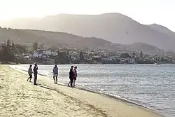
 Nutgrove Beach looking toward Sandy Bay homes and kunanyi / Mount Wellington. | |
 Nutgrove Beach | |
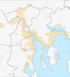
| Coordinates: 42°54′31.64″S 147°21′4.21″E / 42.9087889°S 147.3511694°E | |
| Location | Sandy Bay, Hobart, Tasmania, Australia |
| Offshore water bodies | River Derwent |
| Dimensions | |
| • Length | 700 m (2,300 ft)[1] |
| Patrolled by | Surf Life Saving Tasmania |
| Hazard rating | 2/10 (Least hazardous)[1] |
| Access | Footpath, Nutgrove Avenue, Sandown Avenue |
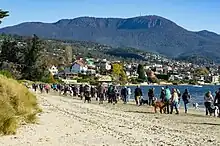
Nutgrove Beach is a popular beach destination along the River Derwent in Sandy Bay, Hobart, Tasmania. The north facing beach has views of kunanyi / Mount Wellington, Lords Beach, Wrest Point Hotel Casino, the Tasman Bridge, and the City of Clarence on the eastern shore. Nutgrove Beach neighbours Long Beach and Red Chapel Beach, and is within close proximity to the Sandy Bay Sailing Club and Lower Sandy Bay shops. The beach is dog-friendly[2] and has bathroom facilities.
History
Nutgrove Beach has historically been a popular staple of local activity, used for horse races, regattas, sailing races and swimming.
Prior to the British colonisation of Tasmania, the land had been occupied for possibly as long as 35,000 years[3] by the semi-nomadic Mouheneener people, a sub-group of the Nuennone, or "South-East tribe".[4] The Mouheneener held a permanent settlement on neighbouring Long Beach called kreewer.[5][6]
Originally Nutgrove Beach was a continuation of Long Beach. As a means in preventing further foreshore erosion, a basalt seawall was constructed in the 1970s, dividing the beach in two. The new beach was named Nutgrove Beach after nearby Nutgrove House, an 1880s homestead built by John T. Read, a farmer who owned the Kinvarra Estate in Plenty. Read named his house "Nutgrove" after a small grove of walnut trees growing on the land. There were many apple, pear and nut orchards in Lower Sandy Bay in the 19th century.[7] Nutgrove House still stands today.
Marine life

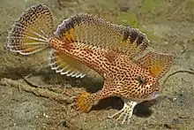
Nutgrove Beach is home to many sea creatures, including the native smooth spotted shore crab (Paragrapsus laevis)[8] and the critically endangered spotted handfish (Brachionichthys hirsutus).[9] Though once a calving ground of the southern right whale (Eubalaena australis), it is now incredibly rare to sight a whale in the Derwent estuary.[10] Whaling was banned in Australia in 1978,[11] and ships are not to approach closer than 100 metres (330 ft) when encountering whales.[12]
Environment

In 2015, a survey report found that over 40 houses along Nutgrove beach are at risk from rising sea levels.[13] In 2018, an annual report revealed that Blackmans Bay and Nutgrove Beach contained the worst water quality within the Derwent estuary.[14]
Access
Nutgrove Beach is a one-hour walk from the Hobart City Centre, or a short metro bus ride along Sandy Bay Road.
References
- 1 2 "Nutgrove Beach, Sandy Bay, Hobart, Tasmania". beachsafe.org.au. Retrieved 21 June 2022.
- ↑ "Nutgrove Beach - Sandy Bay". dogwalkingtas.org.au. Retrieved 21 June 2022.
- ↑ "History of Tasmania". Encyclopædia Britannica. Retrieved 21 June 2022.
- ↑ Horton, David, ed. (1994). The Encyclopedia of Aboriginal Australia. Canberra: Aboriginal Studies Press. (See: Vol. 2, pp.1008–10 [with map]; individual tribal entries; and the 'Further reading' section on pp.1245–72).
- ↑ "Derwent River: Long Beach (aka Sandy Bay Beach)". tasmanianbeaches.net. Retrieved 5 July 2022.
- ↑ "Sandy Bay". palawa-places.org.au. Retrieved 5 July 2022.
- ↑ "The Names Of Hobart: River Derwent". ourtasmania.com.au. Retrieved 21 June 2022.
- ↑ "Species of the Derwent: Shore Crab". derwentestuary.org.au. Retrieved 21 June 2022.
- ↑ Bourke, Ed (18 June 2022). "'It's all a bit hard for them really': critically endangered handfish saved at Nutgrove Beach". The Mercury. Retrieved 21 June 2022.
- ↑ "WHALE SEEN IN DERWENT". The Mercury (Hobart). 4 June 1951. p. 6. Retrieved 10 July 2022 – via National Library of Australia.
- ↑ "History of whaling in Australia". Department of Climate Change, Energy, the Environment and Water. Retrieved 10 July 2022.
- ↑ Kempton, Helen (23 November 2017). "Whale spotting in River Derwent prompts warnings about rules". The Mercury. Retrieved 21 June 2022.
- ↑ Luttrell, Alex (31 May 2015). "Experts urge action plan for Sandy Bay as the rising tide becomes a threat to beachside houses". The Mercury. Retrieved 21 June 2022.
- ↑ Baker, Emily (22 January 2019). "Blackmans Bay, Nutgrove Beach worst for water quality within Derwent". The Mercury. Retrieved 21 June 2022.