| District of Upper Alsace Bezirk Oberelsaß (in German) | |||||||||
|---|---|---|---|---|---|---|---|---|---|
| District of Alsace-Lorraine | |||||||||
| 1871–1918 | |||||||||
 Flag
 Coat of arms
| |||||||||
.jpg.webp) Upper Alsace district with its subdistricts in different colours (1890) | |||||||||
| Capital | Kolmar | ||||||||
| Area | |||||||||
• 1885 | 3.508 km2 (1.354 sq mi) | ||||||||
• 1910 | 3.508 km2 (1.354 sq mi) | ||||||||
| Population | |||||||||
• 1885 | 462.549 | ||||||||
• 1910 | 517.865 | ||||||||
| History | |||||||||
| 1870–1871 | |||||||||
• Established | 1871 | ||||||||
• Disestablished | 1918 | ||||||||
| Political subdivisions | 6 rural districts | ||||||||
| |||||||||
| Today part of | France | ||||||||
| Part of a series on |
| Alsace |
|---|
|
|
Oberelsaß (or Upper Alsace, French: Haute-Alsace) was the southern part of the historical region Alsace or Elsass, inhabited originally by locals speaking Alemannic German. From 1871 to 1918, Bezirk Oberelsaß was a region (Bezirk) in the southern part of the province of Elsaß-Lothringen in the German Empire. The region corresponds exactly to the current French department of Haut-Rhin. Its capital was Colmar. It was divided into the districts (Kreise) of:
- Altkirch within the Sundgau
- Colmar
- Gebweiler (Guebwiller)
- Mülhausen (Mulhouse)
- Rappoltsweiler (Ribeauvillé)
- Thann
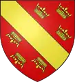
The flag of Oberelsaß is a yellow bar on a red field decorated on each side with three crowns. The combination of this flag with that of Unterelsaß forms the flag of modern Alsace.
This article is issued from Wikipedia. The text is licensed under Creative Commons - Attribution - Sharealike. Additional terms may apply for the media files.

.svg.png.webp)