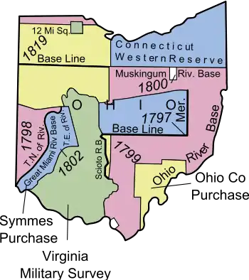
Map of the Ohio Lands
The Ohio Lands were the several grants, tracts, districts and cessions which make up what is now the U.S. state of Ohio. The Ohio Country was one of the first settled parts of the Midwest, and indeed one of the first settled parts of the United States beyond the original Thirteen Colonies. The land that became first the anchor of the Northwest Territory and later Ohio was cobbled together from a variety of sources and owners.
List of Ohio Lands
- Canal Lands
- College Township
- Congress Lands or Congressional Lands (1798–1821)
- Connecticut Western Reserve
- Dohrman Tract
- Ephraim Kimberly Grant
- Firelands or Sufferers' Lands
- Fort Washington
- French Grant
- Indian Land Grants
- Maumee Road Lands
- Michigan Survey or Michigan Meridian Survey or Toledo Tract
- Ministerial Lands
- Moravian Indian Grants
- Ohio Company of Associates
- Refugee Tract
- Salt Reservations or Salt Lands
- School Lands
- Seven Ranges or Old Seven Ranges
- Symmes Purchase or Miami Purchase and/or the Land Between the Miamis
- Toledo Strip, object of a nearly bloodless war between Ohio and Michigan
- Turnpike Lands
- Twelve-Mile Square Reservation
- Two-Mile Square Reservation
- United States Military District
- Virginia Military District
- Zane's Tracts or Zane's Grant or Ebenezer Zane Tract (see Zane's Trace)
See also
External links
- The Evolution of Ohio (OPLIN)
- Knepper, George W. (2002). The Official Ohio Lands Book (PDF). The Auditor of the State of Ohio.
- Ohio Department of Natural Resources. Original Land Subdivisions of Ohio (PDF). ODNR, Division of Geological Survey. Map MG-2. 2003/2006. (Archived from original).
- American Surveyor article
This article is issued from Wikipedia. The text is licensed under Creative Commons - Attribution - Sharealike. Additional terms may apply for the media files.