Okcheon
옥천군 | |
|---|---|
| Korean transcription(s) | |
| • Hangul | 옥천군 |
| • Hanja | 沃川郡 |
| • Revised Romanization | Okcheon-gun |
| • McCune-Reischauer | Okch'ŏn-gun |
 Flag  Emblem of Okcheon | |
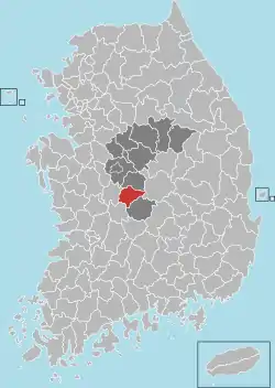
 Location in South Korea | |
| Country | |
| Region | Hoseo |
| Administrative divisions | 1 eup, 8 myeon |
| Area | |
| • Total | 537.13 km2 (207.39 sq mi) |
| Population (2004) | |
| • Total | 56,634 |
| • Density | 114/km2 (300/sq mi) |
| • Dialect | Chungcheong |
Okcheon County (Okcheon-gun) is a county in North Chungcheong Province, South Korea.
Climate
Okcheon has a humid continental climate (Köppen: Dwa), but can be considered a borderline humid subtropical climate (Köppen: Cwa) using the −3 °C (27 °F) isotherm.
| Climate data for Okcheon (1993–2020 normals) | |||||||||||||
|---|---|---|---|---|---|---|---|---|---|---|---|---|---|
| Month | Jan | Feb | Mar | Apr | May | Jun | Jul | Aug | Sep | Oct | Nov | Dec | Year |
| Mean daily maximum °C (°F) | 3.6 (38.5) |
6.6 (43.9) |
12.7 (54.9) |
19.4 (66.9) |
24.8 (76.6) |
28.2 (82.8) |
29.9 (85.8) |
30.6 (87.1) |
26.2 (79.2) |
20.5 (68.9) |
13.1 (55.6) |
5.6 (42.1) |
18.4 (65.1) |
| Daily mean °C (°F) | −2.2 (28.0) |
0.3 (32.5) |
5.7 (42.3) |
12.1 (53.8) |
17.7 (63.9) |
22.2 (72.0) |
25.0 (77.0) |
25.3 (77.5) |
20.1 (68.2) |
13.1 (55.6) |
6.5 (43.7) |
−0.3 (31.5) |
12.1 (53.8) |
| Mean daily minimum °C (°F) | −7.4 (18.7) |
−5.2 (22.6) |
−0.6 (30.9) |
5.3 (41.5) |
11.1 (52.0) |
16.9 (62.4) |
21.3 (70.3) |
21.5 (70.7) |
15.7 (60.3) |
7.7 (45.9) |
0.9 (33.6) |
−5.3 (22.5) |
6.8 (44.2) |
| Average precipitation mm (inches) | 21.3 (0.84) |
32.5 (1.28) |
48.0 (1.89) |
74.4 (2.93) |
74.4 (2.93) |
141.6 (5.57) |
284.0 (11.18) |
265.2 (10.44) |
133.3 (5.25) |
56.4 (2.22) |
44.4 (1.75) |
23.8 (0.94) |
1,199.3 (47.22) |
| Average precipitation days (≥ 0.1 mm) | 4.8 | 4.9 | 6.9 | 7.4 | 6.9 | 7.9 | 14.0 | 13.1 | 8.0 | 5.1 | 6.7 | 5.7 | 91.4 |
| Source: Korea Meteorological Administration[1] | |||||||||||||
Twin towns – sister cities
Okcheon is twinned with:
Prominent individuals
- Jeong Ji-yong, modernist poet
- Song Si-yeol, Joseon statesman, Neo-Confucian scholar and philosopher
- Yuk Young-soo First Lady of Korea, killed during an assassination attempt on her husband, Park Chung Hee
- Mijoo, member of K-pop girl group Lovelyz
- Keum Donghyun, member of K-pop boy group Epex
References
- ↑ "Climatological Normals of Korea (1991 ~ 2020)" (PDF) (in Korean). Korea Meteorological Administration. Archived from the original (PDF) on 29 January 2022. Retrieved 7 June 2023.
- ↑ "International Exchange". List of Affiliation Partners within Prefectures. Council of Local Authorities for International Relations (CLAIR). Archived from the original on 22 November 2015. Retrieved 21 November 2015.
External links
36°18′03″N 127°34′07″E / 36.3008333433°N 127.568611121°E
This article is issued from Wikipedia. The text is licensed under Creative Commons - Attribution - Sharealike. Additional terms may apply for the media files.
