| Pah Rah Range | |
|---|---|
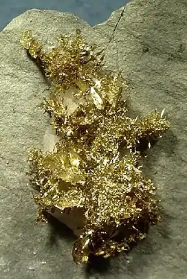
 Gold from Olinghouse district | |
| Highest point | |
| Peak | Virginia Peak |
| Elevation | 2,547 m (8,356 ft) |
| Geography | |
| Country | United States |
| State | Nevada |
| District | Washoe County |
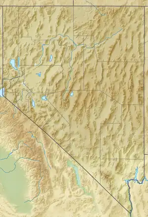
| Range coordinates | 39°45.3′N 119°27.7′W / 39.7550°N 119.4617°W |
| Topo map | USGS Nixon, Wadsworth and Spanish Springs Valley 15 minute quads |
The Pah Rah Range is a mountain range located in western Nevada in Washoe County just to the northeast of Reno. It is a hook shaped range with the main eastern portion oriented northwest–southeast, approximately 20 miles (32 km) long. The northwest flowing Cottonwood Creek in Warm Springs Valley is bounded on three sides by the range. To the south and east the Truckee River forms the boundary and Pyramid Lake is at the northeast. Spanish Springs Valley north of Reno forms the southwest margin. To the north, the narrow Mullen Pass separates the Pah Rah Range from the Virginia Mountains.
The highest peaks (in order from south to north) are Pond Peak (elevation 8,035 ft (2,449 m)),[2] Virginia Peak (elevation 8,357 ft (2,547 m)) and Pah Rah Peak (elevation 8,249 ft (2,514 m)).[3] In the southwest portion Spanish Springs Peak (elevation 7,404 ft (2,257 m)) is the highest.[4] Both Pond Peak and Virginia Peak host several radio towers. Virginia Peak is also the site of a doppler radar station.
Interstate 80 follows the Truckee River basin to the south of the range. Nevada State Route 445 follows the Spanish Springs Valley to the west of the range, Nevada State Route 446 crosses through Mullen Pass to the north and Nevada State Route 447 follows the lakeshore and the Truckee Valley on the east side of the range.[5]
The Pyramid Lake Indian Reservation occupies the eastern portion of the range.
"Pah Rah" is a Paiute term which translates roughly to "Lake Mountain" in reference to Pyramid Lake adjacent to the northeast margin of the range. This term applies to the Virginia Mountains better. This apparent mix-up is likely due to confusion on the part of the early surveyors of the region.
Olinghouse mining district
The former community[6] and historic mining district[7] of Olinghouse is located in the southeastern foothills of the Pah Rah Range about 8 miles (13 km) WNW of Wadsworth, Nevada and 2 miles (3.2 km) east of Pond Peak.[8] The mines of the district produced gold from placer deposits and veins associated with granite porphyry dikes in a faulted basaltic to andesitic volcanic terrain of Oligocene to Miocene age.[9] Mining for gold as collector's specimens occurred during the late 1990s and early 2000s.[9]
The area had four names: White Horse, McLanesville, Ora and finally Olinghouse.[10] The district and the former town that served it were named for Elias Olinghouse, who settled there and ran a mule team transport service.[11][12]
The Olinghouse post office was in operation from October 1903 until July 1923.[13]
Fauna of Pah Rah Range
Wildlife of the range include pronghorn antelope, bighorn sheep, coyote, mountain lion and the wild horse. The bighorn was seen wandering in the foothills of the range in Sparks(Wingfield Springs).[14] It is thought to be from a group of bighorns transplanted to the nearby Virginia Range. Bird species include golden eagles, prairie falcons and red-tailed hawks.[15] [16] [17]
References
- ↑ "Pah Rah Range". Geographic Names Information System. United States Geological Survey, United States Department of the Interior. Retrieved 2009-05-03.
- ↑ Wadsworth, NV, 15 min. topographic quad., USGS, 1957
- ↑ Nixon, NV, 15 min. topographic quad., USGS, 1957
- ↑ Spanish Springs Valley, NV, 15 min. topographic quad., USGS, 1957
- ↑ Reno, Nevada–California, 30x60 minute topographic quad., USGS, 1980
- ↑ U.S. Geological Survey Geographic Names Information System: Olinghouse
- ↑ U.S. Geological Survey Geographic Names Information System: Olinghouse Mining District
- ↑ Olinghouse, NV, 7.5 minute topographic quad., USGS, 1985
- 1 2 Kleine, Scott; Gold Issue, Rocks & Minerals Magazine, Jan-Feb 2004
- ↑ Cerveri, Doris (May 1969). "Town with Four Names" (PDF). Desert Magazine. pp. 33–34. Retrieved April 14, 2020.
- ↑ Carlson, Helen S. (1985). Nevada place names : a geographical dictionary. Reno: University of Nevada Press. p. 180. ISBN 0-87417-094-X.
- ↑ Federal Writers' Project (1941). Origin of Place Names: Nevada (PDF). W.P.A. p. 71.
- ↑ U.S. Geological Survey Geographic Names Information System: Olinghouse Post Office
- ↑ DeLong, Jeff (January 16, 2015). "Bighorn wanders through Sparks". Reno Gazette-Journal. Retrieved April 14, 2020.
- ↑ "Nevada - Plant and animal life". Encyclopædia Britannica. Retrieved April 14, 2020.
- ↑ "Official Checklist of the Birds of Nevada". Great Basin Bird Observatory. Retrieved April 14, 2020.
- ↑ "Pah Rah Virginia PMU Plan: Pah Rah-Virginia Population Management Unit Population Conservation Plan" (PDF). Nevada Department of Wildlife. Retrieved April 14, 2020.

