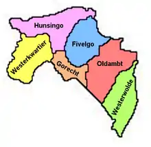
Map of Groningen and Ommelanden
The Ommelanden (Dutch pronunciation: [ˈɔməˌlɑndən]; Surrounding Lands) are the parts of Groningen province that surround Groningen city. Usually mentioned as synonym for the province in the expression Stad en Ommeland ("city and surrounding lands").
.svg.png.webp)
Flag of the Ommelanden
The area was Frisian-speaking, but under the influence of the Saxon city of Groningen most of the area turned to speaking Low Saxon. A reminder of the Frisian past is the Ommelanden flag which looks a lot like the Frisian provincial flag but has more and narrower stripes and more red pompeblêden (stylised heart-shaped leaves of yellow water-lily).
The area is made up of the following four quarters:
References
External links
- Medieval Germany
- Burge's Commentaries on Colonial and Foreign Laws
- Approaches to Old Frisian Philology
53°18′N 6°42′E / 53.3°N 6.7°E
This article is issued from Wikipedia. The text is licensed under Creative Commons - Attribution - Sharealike. Additional terms may apply for the media files.