Oranjestad | |
|---|---|
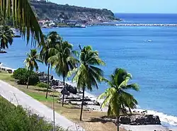
 Beach of Lower Town. | |
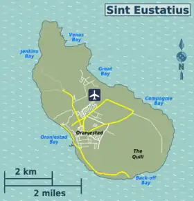
 Location on the island of Sint Eustatius | |
| Coordinates: 17°29′N 62°59′W / 17.483°N 62.983°W | |
| Country | Netherlands |
| Public body | Sint Eustatius |
| Population (2001)[1] | |
| • Total | 1,038 |
| Time zone | UTC-4 (AST) |
| Climate | Aw |
| Oranjestad Lighthouse | |
| Constructed | 1893 (first) |
| Foundation | concrete base |
| Construction | metal skeletal tower |
| Height | 20 metres (66 ft) |
| Shape | square pyramidal skeletal tower with balcony and light[2][3] |
| Power source | solar power |
| Focal height | 40 metres (130 ft) |
| Range | 17 nautical miles (31 km; 20 mi) |
| Characteristic | Fl (3) W 15s. |
Oranjestad (Dutch pronunciation: [oːˈrɑɲəstɑt]; English: Orange[4] Town) is a small town of 1,038 inhabitants;[1] it is the capital and largest town of the island of Sint Eustatius in the Caribbean Netherlands. It’s not to be confused with the far larger Oranjestad in Aruba.
Geography
Oranjestad is a historic harbour town which is divided into two main sections. Lower Town is a strip of buildings just above sea level along the waterfront, which borders on the island's safest beach. Lower Town includes dive shops, numerous colonial-era ruins, and the harbour. Upper Town has a restored historic core, and is also the island's main commercial and residential centre.
History
Historical sites


The first colonist arrived between 1625 and 1629.[5] Sint Eustatius produced sugar and cotton, but most importantly developed into a centre of the North American slave trade.[6] In 1780, the island had an estimated population of 20,000 people including slaves. In 1781, during the Fourth Anglo-Dutch War, the island was captured and plundered by George Rodney.[5] During the capture, all archives were destroyed.[7] In 1786, it was home to 7,600 people (3,000 white, 600 coloureds and 4,000 slaves). In 1829, the population had decreased to 2,273.[5]
The main historical site in Oranjestad is Fort Oranje, a well-maintained, 17th-century fort in the direct centre of the town, overlooking the waterfront. This cliff-side fort has cannons, intact bastions and a courtyard. Nearby is a museum, the ruins of one of the oldest synagogues in the Western Hemisphere, and a Jewish cemetery.[8]
The town's historical features also include a Dutch Reformed church built in 1755,[8] which is partly in ruins but still accessible (its tower can be climbed for long-distance views), various restored 18th-century merchants' residences – including the oldest one, the Gezaghebber House (former Lieutenant Governor's residence) on Kerkstraat – and restored wooden Caribbean-style houses. Snorkeling in Oranje Bay is also interesting because of the parts of 18th century buildings on the bay side that were swept into the sea.[9]
Facilities
Oranjestad itself contains grocery stores, restaurants, bars, a library, schools, a clinic and the administrative offices of the government.
Climate
| Climate data for Oranjestad, Sint Eustatius, 1971-2000 normals | |||||||||||||
|---|---|---|---|---|---|---|---|---|---|---|---|---|---|
| Month | Jan | Feb | Mar | Apr | May | Jun | Jul | Aug | Sep | Oct | Nov | Dec | Year |
| Record high °C (°F) | 31.0 (87.8) |
31.3 (88.3) |
31.7 (89.1) |
33.1 (91.6) |
32.9 (91.2) |
33.5 (92.3) |
33.6 (92.5) |
33.9 (93.0) |
33.7 (92.7) |
34.3 (93.7) |
33.5 (92.3) |
31.4 (88.5) |
34.3 (93.7) |
| Mean daily maximum °C (°F) | 28.3 (82.9) |
28.4 (83.1) |
28.8 (83.8) |
29.4 (84.9) |
30.1 (86.2) |
30.8 (87.4) |
31.1 (88.0) |
31.2 (88.2) |
31.0 (87.8) |
30.6 (87.1) |
29.8 (85.6) |
28.7 (83.7) |
29.9 (85.7) |
| Daily mean °C (°F) | 25.3 (77.5) |
25.2 (77.4) |
25.5 (77.9) |
26.2 (79.2) |
27.1 (80.8) |
27.9 (82.2) |
28.0 (82.4) |
28.1 (82.6) |
27.9 (82.2) |
27.4 (81.3) |
26.6 (79.9) |
25.5 (77.9) |
26.7 (80.1) |
| Mean daily minimum °C (°F) | 22.5 (72.5) |
22.3 (72.1) |
22.7 (72.9) |
23.3 (73.9) |
24.1 (75.4) |
25.0 (77.0) |
24.9 (76.8) |
25.0 (77.0) |
24.7 (76.5) |
24.4 (75.9) |
23.7 (74.7) |
23.1 (73.6) |
23.8 (74.9) |
| Record low °C (°F) | 19.0 (66.2) |
18.9 (66.0) |
18.4 (65.1) |
19.4 (66.9) |
19.1 (66.4) |
21.6 (70.9) |
21.0 (69.8) |
21.0 (69.8) |
21.0 (69.8) |
18.8 (65.8) |
19.3 (66.7) |
18.7 (65.7) |
18.4 (65.1) |
| Average rainfall mm (inches) | 52.0 (2.05) |
50.5 (1.99) |
48.8 (1.92) |
55.7 (2.19) |
87.1 (3.43) |
60.6 (2.39) |
74.1 (2.92) |
106.9 (4.21) |
123.2 (4.85) |
106.5 (4.19) |
128.6 (5.06) |
74.6 (2.94) |
985.8 (38.81) |
| Average rainy days (≥ 1.0 mm) | 11.1 | 8.9 | 7.6 | 7.4 | 9.5 | 7.4 | 11.2 | 12.1 | 12.2 | 11.2 | 13.3 | 12.6 | 125.4 |
| Source: Meteo Curacao[10] | |||||||||||||
See also
References
- 1 2 "Geodata 2001, Saba & Sint.Eustatius, Census 2001". Centraal Bureau voor de Statistiek, Netherlands Antilles. 2001. Retrieved 3 May 2021.
Sum of Oranjestad Noord, Oranjestad Zuid, Concordia and Golden Rock
- ↑ Rowlett, Russ. "Lighthouses of Saba and Sint Eustatius". The Lighthouse Directory. University of North Carolina at Chapel Hill. Retrieved 2017-01-27.
- ↑ List of Lights, Pub. 110: Greenland, The East Coasts of North and South America (Excluding Continental U.S.A. Except the East Coast of Florida) and the West Indies (PDF). List of Lights. United States National Geospatial-Intelligence Agency. 2016.
- ↑ The House of Orange-Nassau — Dutch: Het Huis Oranje-Nassau — read Prince of Orange (Dutch: Prins van Oranje) and related articles for more.
- 1 2 3 Benjamins & Snelleman 1917, p. 627.
- ↑ Benjamins & Snelleman 1917, p. 629.
- ↑ Benjamins & Snelleman 1917, p. 93.
- 1 2 "Sint-Eustatius en alles wat reizen boeiend maakt". Groen Rood Wit (in Dutch). Retrieved 4 May 2021.
- ↑ Peter van Dun; Ben de Vries (2002). "Monumenten Boven de Wind". Jaarboek Monumentenzorg (in Dutch). pp. 139–140.
- ↑ "SUMMARY OF CLIMATOLOGICAL DATA, PERIOD 1971 - 2000" (PDF). Meteo Curacao. Retrieved February 6, 2021.
Bibliography
- Benjamins, Herman Daniël; Snelleman, Johannes (1917). Encyclopaedie van Nederlandsch West-Indië (in Dutch). Leiden: Martinus Nijhoff Publishers.
{{cite book}}:|website=ignored (help)