Highway 155 | ||||
|---|---|---|---|---|
| Ruta 155 | ||||
| Route information | ||||
| Maintained by Puerto Rico DTPW | ||||
| Length | 69.0 km[1] (42.9 mi) | |||
| Existed | 1953[2]–present | |||
| Major junctions | ||||
| South end | ||||
| ||||
| North end | ||||
| Location | ||||
| Country | United States | |||
| Territory | Puerto Rico | |||
| Municipalities | Coamo, Orocovis, Morovis, Vega Baja | |||
| Highway system | ||||
| ||||
| ||||


Puerto Rico Highway 155 (PR-155) is a rural road that goes from Coamo, Puerto Rico to Vega Baja through Orocovis and Morovis.[3] It extends from PR-14 in downtown Coamo to PR-2 east of downtown Vega Baja.[4]
 Puerto Rico Highway 155 south in Orocovis
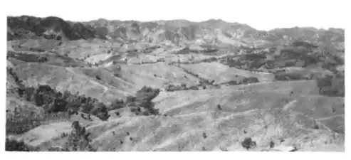 Damián Arriba Fault (from PR-155 looking southwest)[5]
Major intersections
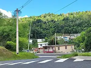
 PR-155 south at its junction with PR-5555 east in Orocovis
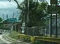 Puerto Rico Highway 155 in Morovis
 PR-155 and PR-634 signs in Morovis
| Municipality | Location | km[1] | mi | Destinations | Notes |
|---|---|---|---|---|---|
| Coamo | Coamo barrio-pueblo | 0.0 | 0.0 | Southern terminus of PR-155; one-way street; eastbound access via Calle Florencio Santiago | |
| Pasto | 2.3 | 1.4 | |||
| 4.6 | 2.9 | ||||
| 5.8 | 3.6 | ||||
| Coamo–Orocovis municipal line | Hayales–Bauta Arriba– Bermejales tripoint | 16.1 | 10.0 | ||
| Orocovis | Saltos | 22.1 | 13.7 | ||
| Orocovis–Orocovis barrio-pueblo line | 27.4 | 17.0 | |||
| 27.5 | 17.1 | ||||
| Orocovis | 28.2 | 17.5 | |||
| 28.6 | 17.8 | ||||
| 30.3 | 18.8 | ||||
| Morovis | Río Grande–Morovis Sud line | 44.0 | 27.3 | ||
| Morovis Sud | 46.2 | 28.7 | |||
| Monte Llano | 46.6 | 29.0 | |||
| Morovis barrio-pueblo | 47.1 | 29.3 | One-way streets | ||
| Morovis Norte | 47.5 | 29.5 | |||
| 48.2 | 30.0 | ||||
| 50.5 | 31.4 | ||||
| Morovis Norte–Torrecillas– Fránquez tripoint | 50.7 | 31.5 | |||
| Barahona | 53.8 | 33.4 | |||
| Fránquez | 55.3 8.7[lower-alpha 1] | 34.4 5.4 | Southern terminus of PR-137 concurrency | ||
| Barahona | 8.5[lower-alpha 1] 55.4 | 5.3 34.4 | Northern terminus of PR-137 concurrency | ||
| Barahona–Fránquez line | 55.5 | 34.5 | |||
| Vega Baja | Pugnado Adentro | 57.5 | 35.7 | ||
| Quebrada Arenas | 58.7 | 36.5 | |||
| Pugnado Afuera | 60.5 | 37.6 | |||
| 61.8 | 38.4 | ||||
| Algarrobo–Pugnado Afuera line | 64.8 | 40.3 | |||
| Algarrobo | 66.0 | 41.0 | |||
| 66.8 | 41.5 | ||||
| Cabo Caribe–Río Abajo line | 68.3 | 42.4 | |||
| Cabo Caribe | 69.0 | 42.9 | Northern terminus of PR-155 | ||
1.000 mi = 1.609 km; 1.000 km = 0.621 mi
| |||||
Related route
Highway 5155 | |
|---|---|
| Location | Orocovis |
| Length | 1.3 km[6] (0.81 mi) |
Puerto Rico Highway 5155 (PR-5155) is a north–south road that connects PR-155 with downtown Orocovis. This highways extends from PR-155 south near PR-5156 until its end at PR-5555 near PR-155 north.[7] The entire route is located in Orocovis.
 PR-5155 south at its junction with PR-5555 in Orocovis barrio
| Location | km[6] | mi | Destinations | Notes | |
|---|---|---|---|---|---|
| Orocovis–Orocovis barrio-pueblo line | 0.0 | 0.0 | Southern terminus of PR-5155 | ||
| Orocovis barrio-pueblo | 0.2– 0.3 | 0.12– 0.19 | |||
| Orocovis barrio-pueblo–Orocovis line | 0.6 | 0.37 | One-way street; PR-156 east access (to Barranquitas) is via Calle Luis Muñoz Rivera | ||
| 0.7– 0.8 | 0.43– 0.50 | ||||
| Orocovis | 1.3 | 0.81 | Northern terminus of PR-5155 | ||
| 1.000 mi = 1.609 km; 1.000 km = 0.621 mi | |||||
See also
References
- 1 2 Google (26 March 2020). "PR-155" (Map). Google Maps. Google. Retrieved 26 March 2020.
- ↑ "Morovis, Memoria Núm. 65" (PDF). Puerto Rico Planning Board (in Spanish). 1955. Retrieved 4 August 2020.
- ↑ National Geographic Maps (2011). Puerto Rico (Map). 1:125,000. Adventure Map (Book 3107). Evergreen, Colorado: National Geographic Maps. ISBN 978-1566955188. OCLC 756511572.
- ↑ "Tránsito Promedio Diario (AADT)". Transit Data (Datos de Transito) (in Spanish). DTOP PR. pp. 83–84. Archived from the original on 1 April 2019.
- ↑ Geological Survey (U.S.) (1949). Geological Survey Bulletin 1184. Geological Survey Bulletin. U.S. Department of the Interior. p. 103. Retrieved 24 July 2021.
- 1 2 Google (6 April 2023). "PR-5155" (Map). Google Maps. Google. Retrieved 6 April 2023.
- ↑ "Mapa de Plan Vial de Orocovis" (PDF). Junta de Planificación (in Spanish). Retrieved 6 April 2023.
External links
Wikimedia Commons has media related to Puerto Rico Highway 155 and Puerto Rico Highway 5155.
This article is issued from Wikipedia. The text is licensed under Creative Commons - Attribution - Sharealike. Additional terms may apply for the media files.