Highway 181 | ||||
|---|---|---|---|---|
| Ruta 181 | ||||
| Route information | ||||
| Maintained by Puerto Rico DTPW | ||||
| Length | 68.65 km[1] (42.66 mi) | |||
| Existed | 1953[2]–present | |||
| Major junctions | ||||
| South end | ||||
| North end | ||||
| Location | ||||
| Country | United States | |||
| Territory | Puerto Rico | |||
| Municipalities | Patillas, Maunabo, Yabucoa, San Lorenzo, Gurabo, Trujillo Alto, San Juan | |||
| Highway system | ||||
| ||||


Puerto Rico Highway 181 (PR-181), also known as Expreso Trujillo Alto,[3] is a road that connects the towns of San Juan, Puerto Rico (very close to Carolina) in the north/northeast coast of Puerto Rico with Patillas in the southeast, passing through the municipalities of San Juan (very small part) at Jesus de Piñero Avenue (PR-17) as it approaches the Teodoro Moscoso Bridge and the Luis Muñoz Marín International Airport, Trujillo Alto, Gurabo, San Lorenzo, Yabucoa and Patillas in the center of the town district near PR-3. Along with PR-10, PR-149, PR-1 and PR-52, it is one of the longest highways crossing the island from north to south through the central mountainous region. In the north part of Trujillo Alto it is a four-lane highway, turning completely rural on the way to Patillas with the exception of a small tract in Gurabo where it intersects PR-30.
Route description
Rural road
In Trujillo Alto, near Gurabo, it turns into a rural road with very narrow lanes per direction and hard curves, making it dangerous and requiring low speed limits. In Gurabo, it becomes divided in about 1 kilometer as it intersects Puerto Rico Highway 30, and then quickly turns rural. In San Lorenzo its makes intersection with Puerto Rico Highway 183. For the rest of its length it is still rural. In Yabucoa, PR-182 begins to connect to the main town, while PR-181 continues and as it enters Patillas, it borders lake Carite, before arriving to downtown Patillas, where it meets PR-3.[1]
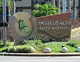 Trujillo Alto marker on PR-181
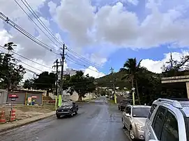 PR-181 north in Gurabo
Major intersections
 PR-30 east at exit 7 to PR-181 in Gurabo
| Municipality | Location | km[4][5] | mi | Destinations | Notes |
|---|---|---|---|---|---|
| Patillas | Patillas barrio-pueblo | 0.0 | 0.0 | Southern terminus of PR-181 | |
| 0.3 | 0.19 | ||||
| Marín | 3.6 | 2.2 | |||
| Patillas–Maunabo municipal line | Marín–Matuyas Alto line | 10.3 | 6.4 | ||
| Yabucoa | Guayabota | 15.1 | 9.4 | Southern terminus of the Ruta Panorámica concurrency | |
| San Lorenzo | Espino | 20.6 | 12.8 | Northern terminus of the Ruta Panorámica concurrency; the Ruta Panorámica continues toward Patillas | |
| 21.7 | 13.5 | ||||
| 22.0 | 13.7 | ||||
| Quebrada Honda | 23.0 | 14.3 | |||
| 24.1 | 15.0 | ||||
| 24.9 | 15.5 | ||||
| Jagual | 28.1 | 17.5 | |||
| Hato–Quemados line | 32.0 | 19.9 | |||
| 32.7 10.3[lower-alpha 1] | 20.3 6.4 | Western terminus of PR-183 concurrency | |||
| 10.6[lower-alpha 1] 32.8 | 6.6 20.4 | Eastern terminus of PR-183 concurrency | |||
| San Lorenzo barrio-pueblo | 33.8 | 21.0 | One-way street; eastbound access via Calle José de Diego | ||
| San Lorenzo barrio-pueblo–Hato line | 34.7 | 21.6 | |||
| Quebrada | 37.9– 38.0 | 23.5– 23.6 | |||
| 38.5 | 23.9 | ||||
| Gurabo | Jaguar | 40.8 | 25.4 | ||
| Jaguar–Mamey line | 42.8 | 26.6 | PR-30 exits 7 and 8; diamond interchange | ||
| Mamey | 43.5 | 27.0 | |||
| Celada | 45.4 | 28.2 | |||
| 45.5 | 28.3 | ||||
| Quebrada Infierno–Masa line | 50.6 | 31.4 | |||
| 54.1 | 33.6 | ||||
| Trujillo Alto | Quebrada Negrito–Dos Bocas line | 58.4 | 36.3 | ||
| Dos Bocas–La Gloria line | 59.5 | 37.0 | |||
| Trujillo Alto barrio-pueblo–La Gloria line | 61.4 | 38.2 | |||
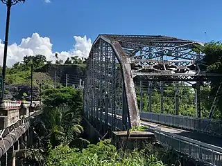
| Río Grande de Loíza | 61.7– 61.9 | 38.3– 38.5 | Puente de Trujillo Alto[6] | ||
| Cuevas–St. Just line | 61.9 | 38.5 | |||
| 63.4 | 39.4 | Southbound exit and entrance | |||
| 63.5– 63.6 | 39.5– 39.5 | ||||
| 63.8 | 39.6 | ||||
| Trujillo Alto–San Juan municipal line | St. Just–Cuevas– Sabana Llana Sur tripoint | 65.3 | 40.6 | ||
| San Juan | Sabana Llana Sur | 65.6 | 40.8 | ||
| Sabana Llana Sur–Oriente line | 67.1– 67.4 | 41.7– 41.9 | Diamond interchange | ||
| Oriente | 68.65 | 42.66 | Northern terminus of PR-181; PR-17 exits 7B and 8 | ||
1.000 mi = 1.609 km; 1.000 km = 0.621 mi
| |||||
See also
References
- 1 2 "Tránsito Promedio Diario (AADT)". Transit Data (Datos de Transito) (in Spanish). DTOP PR. pp. 94–95. Archived from the original on 1 April 2019.
- ↑ "Gurabo, Memoria Núm. 48" (PDF). Puerto Rico Planning Board (in Spanish). 1954. Retrieved 11 August 2020.
- ↑ "Guía de Carreteras Principales, Expresos y Autopistas". DTOP GOV PR (in Spanish).
- ↑ Google (27 March 2020). "PR-181 south" (Map). Google Maps. Google. Retrieved 27 March 2020.
- ↑ Google (27 March 2020). "PR-181 north" (Map). Google Maps. Google. Retrieved 27 March 2020.
- ↑ Luis F. Pumarada O’Neill (1991). "Los Puentes Históricos de Puerto Rico" (PDF) (in Spanish). pp. 109–110. Retrieved 26 March 2020.
External links
 Media related to Puerto Rico Highway 181 at Wikimedia Commons