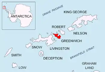
Location of Greenwich Island in the South Shetland Islands.
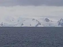
Parchevich Ridge from Bransfield Strait.

Topographic map of Livingston Island, Greenwich, Robert, Snow and Smith Islands.
Parchevich Ridge (Parchevich Rid \'par-che-vich 'rid\) is a partly ice-free ridge of elevation 370 m situated in Breznik Heights north of Hardy Cove, 690 m south of Benkovski Nunatak, and 1.7 km southwest of Santa Cruz Point on Greenwich Island, Antarctica. Surmounting Hardy Cove to the southwest and Gruev Cove to the east-northeast. Bulgarian topographic survey Tangra 2004/05. Named after Petar Parchevich (1612–74), a Bulgarian Catholic bishop and diplomat who campaigned for Bulgarian independence in 1630–45.
Maps
- L.L. Ivanov et al. Antarctica: Livingston Island and Greenwich Island, South Shetland Islands. Scale 1:100000 topographic map. Sofia: Antarctic Place-names Commission of Bulgaria, 2005.
- L.L. Ivanov. Antarctica: Livingston Island and Greenwich, Robert, Snow and Smith Islands. Scale 1:120000 topographic map. Troyan: Manfred Wörner Foundation, 2009. ISBN 978-954-92032-6-4
References
- Parchevich Ridge. SCAR Composite Gazetteer of Antarctica
- Bulgarian Antarctic Gazetteer. Antarctic Place-names Commission. (details in Bulgarian, basic data in English)
External links
- Parchevich Ridge. Copernix satellite image
This article includes information from the Antarctic Place-names Commission of Bulgaria which is used with permission.
This article is issued from Wikipedia. The text is licensed under Creative Commons - Attribution - Sharealike. Additional terms may apply for the media files.