Pasaman Regency
Kabupaten Pasaman | |
|---|---|
 Coat of arms | |
| Motto(s): Saiyo (Agree together) | |
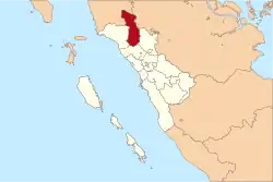 Location within West Sumatra | |
| Coordinates: 0°10′00″N 100°07′01″E / 0.166667°N 100.117°E | |
| Country | Indonesia |
| Province | West Sumatra |
| Regency seat | Lubuk Sikaping |
| Government | |
| • Regent | Sabar AS |
| • Vice Regent | Vacant |
| Area | |
| • Total | 3,947.63 km2 (1,524.19 sq mi) |
| Population (mid 2022 estimate)[1] | |
| • Total | 307,425 |
| • Density | 78/km2 (200/sq mi) |
| Time zone | UTC+7 (IWST) |
| Area code | (+62) 753 |
| Website | pasamankab.go.id |

Pasaman Regency is a regency (kabupaten) of West Sumatra, Indonesia. It has an area of 3,947.63 square kilometres (1,524.19 sq mi) and had a population of 252,981 at the 2010 Census[2] and 299,851 at the 2020 Census;[3] the official estimate as at mid 2022 was 307,425 - comprising 154,712 males and 152,713 females.[1] The regency seat is the town of Lubuk Sikaping.
Pasaman is located in the north-east of West Sumatra. The town of Bonjol, birthplace of Tuanku Imam Bonjol, is notable for being the area where the Trans-Sumatran Highway crosses the equator. Although the majority tribe in West Sumatra is Minangkabau, in Pasaman there is another big tribe, the Mandailing from North Sumatra, so Pasaman means "equality" between two tribes in the Minangkabau language (Indonesian: Persamaan). The first Vice-Regent of Pasaman was H. Ahmad Dahlan Nasution from Duo Koto, King of Sontang (kingdom of Mandailing in Pasaman).
Administrative districts
Pasaman Regency is divided into twelve districts (kecamatan), listed below with their areas and their populations at the 2010 Census[2] and the 2020 Census,[3] together with the official estimates as at mid 2022.[1] The table also includes the locations of the district administrative centres, the number of administrative villages (nagari) in each district, and its post code.
| Name of District (kecamatan) | Area in km2 | Pop'n Census 2010 | Pop'n Census 2020 | Pop'n Estimate mid 2022 | Admin centre | No. of villages | Post code |
|---|---|---|---|---|---|---|---|
| Tigo Nagari | 352.92 | 22,997 | 29,943 | 31,266 | Ladang Panjung | 3 | 26358 |
| Bonjol | 194.32 | 23,184 | 26,282 | 26,717 | Parit | 4 | 26381 |
| Simpang Alahan Mati | 69.56 | 10,580 | 12,384 | 12,667 | Alahan Mati | 2 | 26382 |
| Lubuk Sikaping | 346.50 | 43,746 | 51,092 | 52,240 | Lubuk Sikaping | 6 | 26318 |
| Dua Koto | 360.63 | 24,602 | 28,709 | 29,348 | Simpang Andilan | 2 | 26311 |
| Panti | 194.50 | 35,412 | 34,519 | 35,431 | Panti | 3 | 26351 |
| Padang Gelugur | 178.40 | 21,341 | 32,724 | 33,513 | Tapus | 4 | 26352 |
| Rao | 236.18 | 22,168 | 26,041 | 26,655 | Rao | 2 | 26355 |
| Rao Utara | 598.63 | 10,293 | 12,052 | 12,328 | Koto Rajo | 3 | 26357 |
| Rao Selatan | 338.98 | 21,600 | 26,192 | 26,975 | Lansek Kadok | 2 | 26356 |
| Mapat Tunggul | 605.29 | 8,846 | 10,165 | 10,360 | Lubuk Gadang | 3 | 26353 |
| Mapat Tunggul Selatan | 471.72 | 8,530 | 9,748 | 9,925 | Silayang | 3 | 26354 |
| Totals | 3,947.63 | 253,299 | 299,851 | 307,425 | Lubuk Sikaping | 37 |
References

0°10′00″N 100°07′01″E / 0.166667°N 100.117°E