| Peršėkė | |
|---|---|
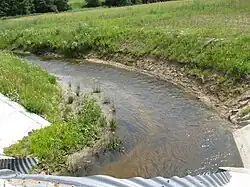 Peršėkė near Mergalaukis | |
| Location | |
| Country | Lithuania |
| Location | Alytus district municipality, Alytus County |
| Physical characteristics | |
| Mouth | Neman |
• coordinates | 54°31′45″N 23°53′32″E / 54.52917°N 23.89222°E |
| Length | 66 km (41 mi) |
| Basin size | 542 km2 (209 sq mi) |
| Discharge | |
| • average | 3.6 m3/s (130 cu ft/s) |
| Basin features | |
| Progression | Neman→ Baltic Sea |
| Tributaries | |
| • left | Metelytė, Atesė, Gluosinė, Varputys, Rudė, Kamaria, Vaičiukupis |
| • right | Paežerėlė, Rudė II, Dūmė |
Peršėkė is a river of Alytus district municipality, Alytus County, southern Lithuania. It flows for 66 kilometres and has a basin area of 542 km².
It begins near Gervėnai village and crosses the Lake Obelija at upper course. There is a water reservoir on Peršėkė near Krokialaukis. The most important settlements near Peršekė are Krokialaukis and Balbieriškis. Peršėkė joins the river Neman from its left side.
References
- LIETUVOS RESPUBLIKOS UPIŲ IR TVENKINIŲ KLASIFIKATORIUS (Republic of Lithuania- River and Pond Classifications). Ministry of Environment (Lithuania). Accessed 2011-11-11.
This article is issued from Wikipedia. The text is licensed under Creative Commons - Attribution - Sharealike. Additional terms may apply for the media files.